Architectural Design and visualization techniques.
A case study: Heusden.
Patricia Alkhoven
|
|
Architectural Design and visualization techniques. A case study: Heusden.
Patricia Alkhoven |
The image and structure of a town are constantly subject to a dynamic process of change and continuity. Repairs, replacement, rehabilitation, redevelopment, demolition, and urban renewal take place in every town, while some areas, however, are left untouched for periods of time. Visual material, such as photographs, historical maps, town plans, drawings and prints, show us the impact of these changes on the image of a town. The main point of departure of this study stems from the question of how this process of change and continuity is visually detectable in a town or city.
The title of this study, The Changing Image of the City1, recalls the by now classic study by Kevin Lynch The Image of the City. Lynch's idea of the images presented in the city, i.e. points of orientation and landmarks, will indeed be used to some extent in the present work, but without the same theoretical implications and only in so far as the urban environment visually presents itself to us. In fact, rather than his 1960 conception of the city as a more static image, the present study makes use of his later idea that there are many mental images of the city2. With this, he means that people look at the city in various ways, they have different ideas about the image of the city and these ideas change over time depending on place, time, social, and economic factors. In the same way, one could say that ideas and preferences in urban management as reflected in plans and realizations for the city change over time. The fact that ideas about the appearance of the city (gradually) change, can in its turn be read from the often subtle changes in the townscape. Though in many cases we have a general knowledge of the choices made in urban management, the most difficult problem is to detect the underlying decisions. This raises the question to what extent these changes and also the continuities are the result of deliberate choices in urban management and to what extent they are autonomous developments in the townscape resistant to interventions.
The English concept of townscape encompasses a wider scope than the Dutch term stadsgezicht, the latter being more directed towards the image, structure and exterior appearance of a town, while townscape is more related to urban history and also includes social, cultural and economic aspects 3. In the present study, townscape is used in a somewhat more concise definition closer to the meaning of stadsgezicht. It refers to the urban reality in the sense of the way the built environment presents itself to us (image) and to the fact that it is a product of decisions related to time and locality. Our definition of townscape is also closely connected to the concept of Protected Townscapes and the instruments for protection and management4.
A Development Plan -obligatory for protected townscapes- is the main instrument for protection and future developments. In practice, decisions concerning the protection and management of a townscape are usually taken on the basis of three main representations of the town which accompany the Development Plan: the (roof) plan, the building masses supplemented with margins of the height of the cornices, and the façade characteristics. In some areas these are supplemented with more or less specifically prescribed façade dimensions and materials5. In addition, the description of listed buildings is being used to determine the façade characteristics in terms of style and decorative elements6.
Focusing on the above-mentioned instruments for management, i.e. the (roof) plan, the building masses, and the façade characteristics as described in the List of Monuments, it should be possible with the help of additional visual material to understand what changes a certain town has undergone over time. Visual material is, however, hardly ever uniform in its representation. The same kind of visual material is not available from all periods. Photographs may show the townscape from different angles and sometimes there are plans available but not drawings of elevations or roof plans. In other words, the available material can in most cases only provide fragments of the changing image of a town. A possible solution would be to make a detailed visual reconstruction of every period or every year based on existing visual material by means of hand-made drawings or physical models. Viewing the drawings of the development of a town in time-sequences would indeed allow for a detailed examination of the changes. It may be clear, however, that such a goal would be rather too ambitious and impossible to complete in a short period of time, since it would take many years to produce graphical reconstructions by hand of every single house in a town for each year and from many different angles.
In the last decade, graphical computer applications have proven to be an increasingly supportive tool in visualization and manipulation of graphical material. At the time this study started, in early 1989, very few Computer-Aided Design studies had been carried out which had reached further than the reconstruction of individual buildings, or the visualization of more than the global morphology of towns7. However, the basic principles had already been established and some good software packages for personal computers had become commercially available. These computer visualization techniques are used in the present study to reconstruct the development of a town three-dimensionally in significant phases. The resulting visualization provides us with a tool for a better understanding of the dynamics of urban transformation processes.
The case study: Heusden
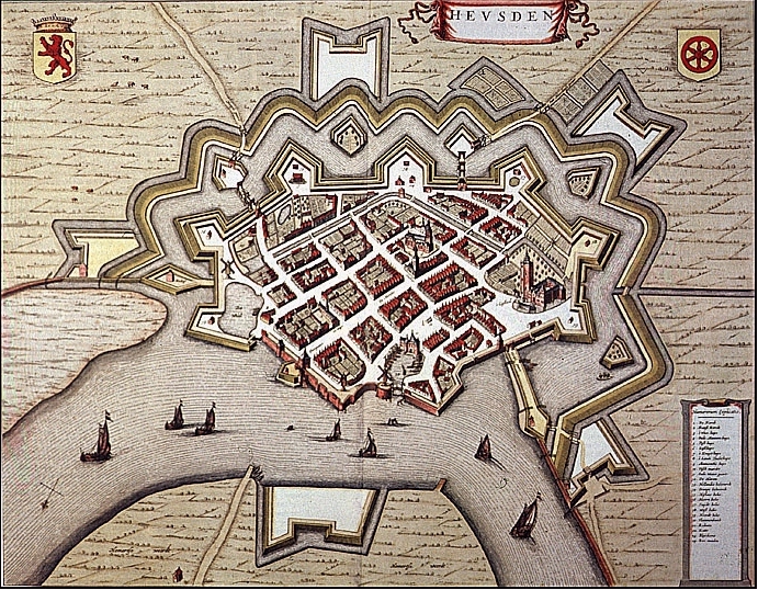
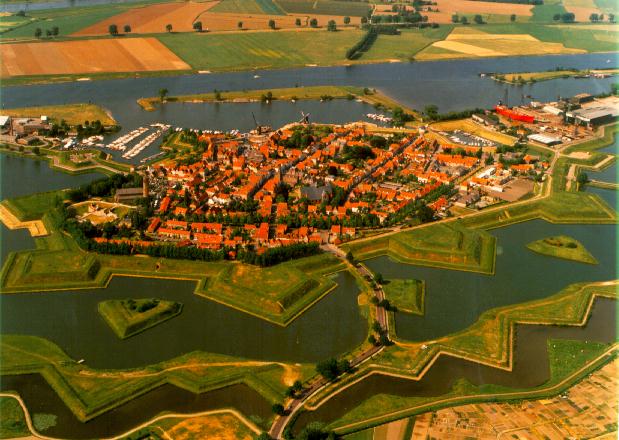
The town of Heusden in The Netherlands has been chosen for a case study. Heusden, enclosed in its system of fortifications, is a well-defined coherent unity, small enough to be studied in its entirety. Most important was the fact that different planning strategies have determined Heusden's image and form in the twentieth century. The focus will therefore be on the urban developments in the twentieth century, a period that is richly documented. For instance, the detailed survey of Heusden's street walls carried out by Ferd. G. Jantzen in 1943 has proven to be an invaluable source of information.
Heusden was founded near a castle probably in the 13th century. It was fortified at the end of the 16th and again at the beginning of the 17th centuries by a fortification system which was modern for its time. During the Dutch Golden Age (17th century) it was a famous garrison town. Heusden, which had been part of the province of Holland from 1357, became part of the much poorer province of Brabant in 1813. After the fortifications had been dismantled in 1816, prosperity declined due to economic factors and the definitive departure of the garrison in 1879. In 1904 the old Town Harbor was filled in and turned into public gardens. Towards the end of World War II, part of the town was destroyed, including the Town Hall and part of the Catharijne Church. During the reconstruction period after the war (1945-1965), a new town hall and a number of council houses were built. Modernist plans in the sixties to level the fortifications and to build multi-story apartment blocks on the outskirts of town were never realized. Instead, a radical restoration plan (Development Plan) was adopted in 1965, involving repair of the fortifications, reconstruction of the historical street structure and restoration and reconstruction of buildings.
The Town Harbor was re-excavated. During this restoration and reconstruction, an old map by J. Blaeu (1649) played an important role for the realization of the reconstructed 17th-century image of Heusden. While the restoration had not yet been finished, Heusden was officially given the status of Protected Townscape in 1972. The restoration campaign was finished around 1990.
This history of Heusden which is well-known in The Netherlands tells us something about the main developments in the twentieth century. Interestingly, during the European Architectural Heritage Year (1975) the restoration of Heusden was presented as a shining example of restoration8. Less than a decade later the same restoration was rejected as a classic example of how it should not be done9. In the light of these events, Heusden seems perfect for an analysis of its changing townscape, the choices made in urban management and their consequences for the image of the town. Architectural plans and realizations of the twentieth century have therefore been visualized with the help of the computer. The selection of material for the visualization focuses on the instruments of the protected townscapes: (roof) plans, building masses, and façade detailing.
Objectives
The objective of the present dissertation is, as reflected in the title, to present a study of the transformation
of the townscape of the town of Heusden using computer visualization techniques. From the title it also
becomes clear that we are dealing with two main goals. The first one is to find answers to questions related
to the case study:
To study the transformation of the townscape (of Heusden) in a detailed way in order to gain knowledge about the dynamics of change and continuity in the building process as reflected in plans and realizations and the choices made in urban management during the twentieth century.
The second deals with the methodological tool for this study:
To use computer visualization techniques as a tool to visualize a town's urban development over time and to get to know to what extent these techniques can help us gain a better understanding of the processes of transformation in the urban environment.
Approach
In order to get a grip on the complexity of the existing city, the study was carried out by means of a formal analysis of the earlier mentioned instruments for protection and management. Rather than to prescribe a certain approach of how urban management should be carried out, the purpose is to show to what extent plans and realizations have an impact on the appearance of the townscape. For the same reason, the quality of the plans and the restoration were not judged in terms of valuation. Nevertheless, detailed knowledge of the history of a site and its buildings can be used in plans for the future, as well as the way in which the basic material has been (re)grouped can contribute to the discussion of urban management.
To be able to complete the entire study within the available four years of time, decisions had to be made with respect to the definition of the working area and the level of detail. To visualize the changes in the townscape at yearly or even at five-yearly intervals would certainly take too much time and it would probably not have been more effective than the definitive decision to visualize the changes in six significant intervals.
Though the study focuses on the 20th century, a sketch of the architectural development of the past in The Netherlands in relation to developments in Heusden is needed to be able to place the existing historical buildings in their architectural historical framework.
Notwithstanding the fact that the case study concerns a town in The Netherlands, the utilization of CAAD as tool of analysis reaches beyond the Dutch situation. This study is therefore written in rather functional English, in order to make the results available for an international audience. The study is intended for people from various fields of interest: for scholars in the humanities interested in the (method of) architectural research of the city (e.g. architects, (architectural) historians), or, in the field of computer applications, for planners or city councils dealing with the protection and management of historical townscapes, and, of course, people interested in the history and visualization of the town of Heusden. Since these target groups are so different, no more than a basic knowledge of town planning and architecture on the one hand and computer applications on the other hand is assumed.
A Dutch town as a case study entails that most of the literature used is written in Dutch. Dutch citations and expressions have therefore been rephrased in English and, where relevant, the original text has been printed in a footnote. Names of persons, institutions and acts, however, are given in Dutch, the approximate translation being given in the text or in a footnote, whenever appropriate.
This study of the changing image of the city, which is the result of four years of work at the University of Utrecht, has offered me the opportunity to combine research to the history of architecture with more `manual' work of making computer images. Producing not only text but also images, enhancing and visually explaining the words in the text, has given me great pleasure and I am grateful to all the people who helped me writing the present study.
I am much indebted first to Prof. dr. Jörgen van den Berg (Computer & Humanities), who became promotor after the initiator of this project, Prof. dr. mr. Wessel Reinink was not in the position to finish his job as promotor. I also like to thank my co-promotor Dr. Rob Dettingmeijer (Department of Architectural History) for the many stimulating discussions over the years.
Special thanks to Dr. Ronald Stenvert who was involved from the start and who offered many valuable suggestions on the subject, and my collegues from the Department of Art History, in particular Drs. Marie Thérèse van Thoor and Drs. Inge Breedveldt Boer, who helped in the editing of the book and assisted me in many other ways.
Many thanks to Astrid Holtman and Andy Baxter, who had the considerable task to correct the English and thereby greatly added to the value of this book.
I am very thankful to Tom van der Aalst, head of the "Streekarchief van het Land van Heusden en Altena" in Heusden whose help and support has litterally opened official doors for me during the research in the town of Heusden, and who transcribed some 16th-century documents for me. I would like to thank the architects Verlaan & Bouwstra (Vianen), R. ten Klooster from the Grontmij B.V. (De Bilt) and, in particular, A. Peetoom (Hoogmade), for their kind cooperation in giving me architectural material on loan for the duration of the project. This has helped me enormously in studying the drawings and which facilitated the making of the three-dimensional computer models. In addition, I thank architect J.C. Meulenbelt (Utrecht) and former town secretary Chr. Lith (Heusden) for their conversations with me.
Many thanks to those who financially aided the publication of this book, in particular, Renderstar Technology B.V. Amsterdam, for their kind cooperation in that I was allowed to use their CAD facilities and especially for their considerable contribution to this book in the form of the final computer images.
But most of all I thank Laurens Lapré, without his incessant encouragement and stimulation and not to mention his
patience and `on-line help' in using the software developed by his hand and our discussions how to make the project work,
this book would have been a completely different one.
Notes
1. Lynch 1960; 1984.
2. Lynch 1984, 159.
3. Cullen 1961; Burke 1976; Kostof 1992, 298-300.
4. See, for Protected Townscapes (Beschermde Stads- en Dorpsgezichten): Rijksdienst voor de Monumentenzorg 1982.
5. The instruments for the management of Protected Townscapes are described in detail in Chapter I. See also: Rijksdienst voor de Monumentenzorg 1982.
6. See, for example: De Geïllustreerde Beschrijving van de Monumenten van Geschiedenis en Kunst.
7. Maver 1987; Maver & Wagter 1988.
8. Heusden was presented in 1975 as a "shining example of restoration" (Lichtend Voorbeeld van restauratie). Scholten 1975B, 40.
9. De Boer 1984, 19.