Architectural Design and visualization techniques.
A case study: Heusden.
Patricia Alkhoven
|
Architectural Design and visualization techniques. A case study: Heusden.
Patricia Alkhoven |
Chapter V. A Computer-Assisted Analysis of Heusden's Changing Townscape
5.2 Global Analysis of Façades
5.3 The Morphology of Heusden's Townscape
In the previous chapters, much space has been devoted to
detailing the process of obtaining information about the changes
(the events) that occurred. This chapter, by contrast, deals with
the visual history of change and with continuity in the
townscape. Whereas in the previous chapter, urban development was
mainly illustrated by means of layers-of-time, i.e.
the six reference dates, this chapter deals with the graphical
computer as a means of ordering and selecting various kinds of
graphical material. In the layers-of-time approach,
only relevant aspects of the town related to a reference date
were combined. The information from the three-dimensional models,
however, can also be analyzed across layers or by theme.
The method used here follows the general description given in
Chapter I. We start with a typology of the buildings in Heusden
and then proceed to a global investigation of the elements of the
city and the relation between the buildings and urban morphology.
In order to finally assess the dynamic process of change and
continuity, the dynamics of the city itself are considered.
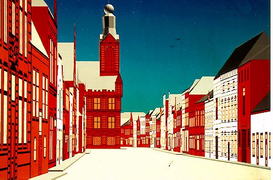
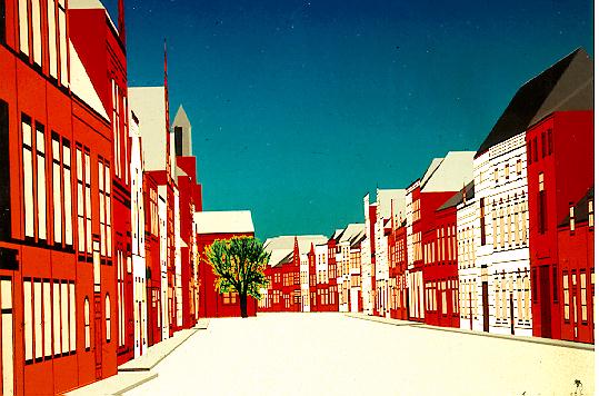
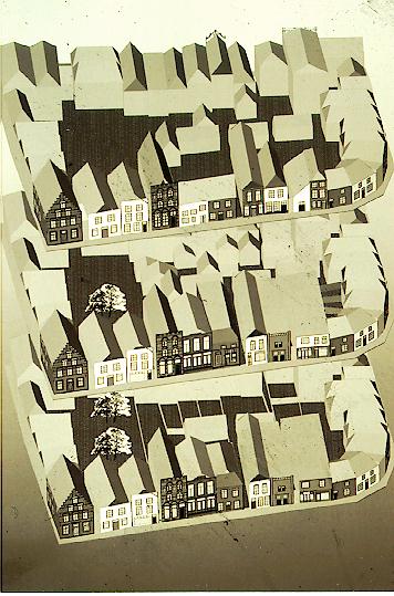
Using the CAD-system as a visual database system, the bitmap
textures of the façades have been ordered in new
combinations, as in the previous chapter, with first the street
walls and then the architect-restored buildings and also
chronologically with respect to their restoration. These
categories were chosen because they appeared most appropriate for
detailed examination. However, many more are possible, and we
also added the category of the façades ordered by century.
These images were used as a basis for the typological analysis
of various aspects of the development of Heusden's townscape: the
development of its buildings and types, its structure and scale,
and its dimensions. The façades of the houses within the
Putterstraat and Burchtterrein area and the waterfront were
surveyed again in the first section by means of computer images.
Here, the treatment of different kinds of façades in the
20th century, the development of styles, types, and functions can
be traced in the computer images.
In the second section, we deal with the spatial morphology of
Heusden and transformation over time, based on the two and three-dimensional models of the 20th-century development used earlier
as illustrations to the previous chapter, and also on the
information from the former chapters. In this way, the typical
elements of Heusden's morphology and how this information was
used after the Second World War is discussed. Here again, it
means that some aspects, already touched upon in general in
Chapter I and with regard to Heusden in Chapters III and IV, need
to be re-assessed in a different way or in some different
combination.
The concluding section deals with how the town has changed.
Rather than showing the influence of conscious management, the computer models can help to make visible urban processes that
proceed more or less independently of planning processes. Topics
such as Heusden's dynamic process of development and the visible
image in the townscape versus the self-image of the town are
assessed.
The changing ideas regarding the townscape can best be seen in
the treatment of the façades. Subtle changes in scale,
proportions, façade openings, can be studied in two-dimensional street wall computer images. Similar to the images
of the street walls, images of buildings from a specific group
were selected and projected side by side. Several new
combinations were created with the bitmap textures, starting with
a classification of the façades per century. In order to
be able to study the development of local building types, the
changing functions of buildings, the treatment of listed and non-listed buildings, it was necessary to make a typological
arrangement.
An attempt at a typological arrangement of façades
immediately involved some complications. Buildings, and lower
fronts in particular, have changed in the course of time. For
example, at Vismarkt 14 the original building construction dates
from c.1600, whereas the lower front was changed around 1850, and
the complete building was restored to its original 17th-century
appearance in 1969. Clearly, there is a problem as to how to
classify this building. Do we choose the original year of its
construction, the 19th-century changes or the latest restoration
for classification purposes? Further, an arrangement per century
also involves the complication of overlapping building styles and
types during a single century. In order to deal with these
problems, Jantzen's drawings were used again as our point of
departure. He not only mentioned the approximate year of
construction of the façades and possible dates of
alteration, he also provided a map of in which the century of
construction of the buildings (16th, 17th, 18th, 19th or 20th)
was indicated. Using the dates mentioned on the map, most of the façades within the area of interest were
investigated and grouped by century. The approximate date of the
façade mentioned in the 1943 drawings served as reference
date3.
Since the typology was based on the volume of the buildings, each
group of buildings from a particular century was further
subdivided according to façade characteristics into listed
and non-listed buildings. This distinction was necessary to study
whether the listed buildings were treated differently from the
non-listed buildings during the restoration period. The listed
and non-listed buildings were further classified into deep
houses (buildings with ridges at right angles to the
street) and transversal houses (buildings with
ridges parallel to the street), and, to a limited extent, the
square house. In addition, they were roughly
classified by height (number of stories), function, and
appearance (gables, cornices, simple dwellings, mansions,
warehouses, town farms, etc). Two other types
mentioned in the Geïllustreerde Beschrijving,
namely, complex houses and the building
block, appeared to be almost completely absent in the area
of interest and therefore did not need to be assigned separate
categories.
The images, ordered per century and displaying the six reference
dates, were used in the present project to examine the changes
in and the treatment of the façades in the 20th century.
This analysis deals with one or sometimes several computer images
at a time. Because the façades have been arranged in
specific groups, they are dealt with in groups, although each
building has its own history. In order to avoid having to
describe each individual building, we choose to focus on some
general aspects and distinctive changes. By arranging most of the
buildings from the area of interest according to this system,
common characteristics become apparent. The system of
classification is pragmatic, and a more detailed or different
ordering of buildings would certainly be possible. However, that
would increase the number of illustrations even more. So, rather
than aiming at a fully elaborated typology, we decided on a more
pragmatic approach focusing on some specific aspects. Though we
mainly used the typology for two-dimensional analysis of the
façades in this section, the same system could be used for
three-dimensional research - the building as spatial form, or the
town block, for example.
We start here with an overview of the building types present in
Heusden and their functions and development, followed by a more
detailed examination of the changes in the façades during
the 20th century.
Development of types and functions
>From the 16th to the 19th century, the arrangements of the
façades of deep houses show a rather limited number of
forms. The arrangement of narrow façades with two bays is
usually 2-2-15. A more current arrangement is the façade
with three bays 3-2-1 or with cornices 3-2 or 3-3, sometimes with
dormers. The higher and more important gables with three bays may
have the arrangement of 3-3-2-1 or 3-2-2-1. Cornices of this type
may have the arrangement of 3-3-3, 3-3-2 or 3-2-2, 2-2-2 for
narrow buildings. These higher buildings can be found in Heusden
along Breestraat, Botermarkt and there are some individual ones
in Hoogstraat, Pelsestraat and Vismarkt. Cellars have been left
out of this study since they are considered part of the interior.
However, the exteriors of the buildings often show cellar (or
former cellar) windows and trapdoors. Transversal houses 1600-1850 in Heusden usually have four or five bays.
Taking into consideration that Heusden is situated between the
provinces of Holland and Brabant and belonged to Holland between
1357 and 1813, it is no surprise that the influence of both
Holland and Brabant architectural style
can be seen. If we take a general look at the buildings present
in Heusden, we see that the building stock presents a variety of
houses.
There are only a few houses left that date from before 1572,
though there are more buildings in which traces from the Middle
Ages can be found6. More or less unaltered façades dating
from before 1600, are - apart from the Town Hall and the church - the corner of Pelsestraat and Putterstraat; Wijksestraat 8;
Waterpoort 1a; Engstraat 6/4. There are several interesting
Dordtse gables and Renaissance stepped and shaped
gables7. These gables were mostly built after the great town
fire of 1572, when a third of the town was reduced to ashes.
Another local type is exemplified by the 18th-century typical
narrow bell gable of Breestraat 17, which has only two
bays8. There are still many buildings with 17th-century
façades, some still with wooden lower fronts, though most
of the buildings were remodeled in later centuries.
Until 1850, building activities in Heusden followed the general
developments described in Chapter I (1.2). In the 18th century,
very few houses were built and most façades were
remodeled. Gables were replaced by cornices which were sometimes
one story higher than before. These buildings did not undergo
many changes in the 19th century, apart from the renovation of
undivided windows and lower fronts. On the other hand,
façades were sometimes remodeled in Neo-Gothic style and
more square mansion-like types of four or five bays wide emerge.
The Post Office (1893), is a 19th-century re-interpretation of
the Brabatian Gothic with trefoiled decoration. Neo-Renaissance architecture is strikingly absent. As mentioned
before, there are also some interesting examples of Jugendstil
and Amsterdam School. After the war, Delft School rows of houses,
the higher maisonette-type with garages below, and some apartment
buildings emerged.
Apart from warehouses that were intentionally built as such, many
dwellings on the point of collapse were, from the 20th century,
used for storage. These were mainly dwellings built in the alleys
and along the Demer Canal, Wijksestraat, and Ridderstraat. During
the period of the restoration they lost their function as
warehouses, since most industries and farming were relocated outside the historic center. Most of the former 17th and 19th-century barns and warehouses were turned into dwellings after the
Second World War. Destroyed barns were not rebuilt but replaced
by new dwellings. This change of function was due to the
decreasing number of active town-farms and the need for good
dwellings after the war. A single barn or warehouse was sometimes
divided into two dwellings. Breestraat 10 was turned into a
community center and the barn is now a lecture room.
During the restoration period, the shopping area became
concentrated in the main street, Vismarkt and the streets
connecting them. Shop windows which were enlarged at the
beginning of this century to take larger panes of glass and later
even undivided windows, were replaced by divided windows after
1965. Symmetry in the façades and the placing of the doors
of shops and dwellings alike was often changed for the sake of
more logical interior division. The front doors of Ridderstraat
5 and Breestraat 13 are now placed symmetrically in
the middle. The appearance of the lower fronts of shops was often
emphasized, as can be seen in the images of Botermarkt.
In general, alteration of scale (subdivision or annexation) does
not seem to have been carried out on a large scale, at least not
until the second half of the 19th century. A few larger houses
were subdivided into two dwellings. However, annexation of
adjacent premises did sometimes occur with shops that expanded.
This can be seen at Vismarkt 14/12/12a, Drietrompetterstraat 15,
Wijksestraat 34, 10, and Botermarkt 21. However, as discussed
in Chapter IV, subdivision into front and back houses or into
ground-floor apartment and upstairs apartments mostly took place
during the recent restoration.
By applying very strict rules, a high degree of uniformity and
standardization was created in the exterior. In general, large
panes of glass were replaced by 2x3 or some smaller division.
Only white mullions and glazing bars were allowed (rather than
green), while doors, on the other hand, had to be painted green,
and red brick and tiled roofs were the obligatory materials.
The changes which have occurred to the façades during the
20th century, and in particular during the period of the
restoration are discussed here on the basis of the computer
images.
- 17th century
Stadshaven 24, which was demolished in the nineteen
fifties, was not rebuilt during the restoration period, nor was
the stepped gable of Vismarkt 7, despite the building's
important location on the marketsquare near the harbor. The
missing upper part of Breestraat 10 was rebuilt in order
to improve the general aspect of the town but none of the
vanished stepped and Dordtse gables (Engstraat and Putterstraat)
were reconstructed.
The treatment of the lower fronts shows the diversity of
approaches taken to restoration9. The 18th-century lower front
of Vismarkt 1 was kept but accentuated with moldings above
the windows and the front door. The lower fronts of Vismarkt 14 and Breestraat 13 were radically reconstructed to
their original appearance with wooden penthouses and stained-glass windows. Though the undivided windows of
Drietrompetterstraat 18 dating from the early 20th century
are completely out of scale, they were not replaced by smaller
ones, nor were the 19th-century H-shaped sash windows of Vismarkt
7 and Engstraat 6 and the Jugendstil windows of Engstraat 2.
Many 17th-century façades were remodeled in the 18th and
19th centuries. 18th-century elements such as 4x3+3 or 3x3+2 sash
windows were usually respected or they were reconstructed while
the overall dimensions did not change. Most 19th-century
façades were kept or received mullioned windows (2x3).
Engstraat 10 was more radically changed during the
restoration period. Its façade is now more of a unity. The
front door of the three-bay-wide lower front of Botermarkt 11 is no longer placed in the middle but now appears on the
right side. In this way a more efficient interior disposition for
the shop was created. Façades with different kinds of
windows (Vismarkt 16, Engstraat 8) were given the same kind of
window in order to restore the unity of the front.
- 18th century
Unlisted buildings were changed more radically. An example of
this is the bell gable of Drietrompetterstraat 15. Its
situation next to the already restored Vismarkt 14 (with
the same owner) probably explains the adaptation of its lower
front. Another change in the townscape was caused by the
restoration of Putterstraat 68, the upper part of whose
front was painted red (colcothar). Some buildings were
deplastered and a few buildings which had been destroyed in
the war were rebuilt in approximately the same style. The more
mansion-like cornice façades hardly underwent any exterior
changes.
- 19th century
Very few of the 19th-century unlisted warehouses have survived.
Most of them were turned into one-family dwellings during the
restoration (Drietrompetterstraat, Waterpoort,
Ridderstraat and the Demer Canal). 19th-century buildings that
had been destroyed in the Second World War were usually not
rebuilt. Some were replaced during the reconstruction period by
blocks of simple row houses11. Other open terrain was not built
upon until the restoration. Although many buildings kept their
19th-century appearance, with only windows being changed, there
are also striking examples of demolition (Waterpoort 17;
Wijksestraat 29/29a). A real transformation in the rhythm of
the street wall was caused by the dormers on 18th and 19th-century houses which were mostly built in the restoration period.
New bedrooms were constructed in lofts which had to be lighted
with dormers or skylights.
Due to increasing industrialization in the second half of the
19th century, many simple workmen's dwellings were built in Putterstraat and alleys. It was mainly these dwellings that were
on the point of collapse in 1955 and were listed for demolition.
They often formed a group of 3 to 5 repeated dwellings, with a
very small ground floor and a bedroom in the loft. The workmen's
dwellings in fact established a new minimum scale in Heusden
since they were at least one floor lower than the average
building, and some were only two bays wide.
Façades from the 17th century with relatively rich
decoration were most radically restored to their original
appearance, whereas 18th-century buildings were surprisingly
little changed during the restoration period. Late 18th-century
windows often replaced the larger undivided late 19th and early
20th century windows. Many simple workmen's dwellings were
constructed in the 19th century but a number of mansions were
also built. Some of these mansions were demolished during the
restoration period but many of the more simple dwellings kept
their features except for the windows, which were usually
replaced by crosswindows or 2x3 windows. Although most of the
19th and early 20th-century H-shaped or undivided windows were
replaced with divided ones, it certainly cannot be said that we
see the complete disappearance of the 19th
century13. There are still many interesting 19th century
façades to admire, such as the Neo-Gothic façades
and the many others with rustication, stucco window framing, and
windows with rounded tops. In general, it appears that listed
buildings, in particular those from the 17th century, were more
radically restored than non-listed buildings.
The façade series help us to make these slight similarities and differences visible and directly available
for consultation. In this way, the research results and
the method are also verifiable by others.
5.3 The Morphology of Heusden's Townscape
Urban morphology was defined in Chapter I as the three-dimensional structure or basic urban structure recorded in
the plan, from which one can read off the built-up and unbuilt-up
areas, roads, streets, bridges, the course of rivers and canals,
public gardens, blocks and squares; and, in addition, one
can also see clearly the building masses. Some aspects of these
matters have already been touched upon in previous chapters. In
order to be able to deal with the urban structure in more detail,
the elements which make up the town of Heusden
needed to be investigated and analyzed. This involved the
examination of the lay-out of the streets, the types of squares,
and the dimensions of the buildings. In addition, the
relationship between the urban elements and the underlying urban
structure are discussed. This analysis was based on the study of
town plans as described in Chapter III and on the street walls
and three-dimensional computer models.
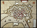
As discussed in Chapter III, the geographical situation is
fundamental for the form and formation of a town. The main street
(Breestraat, Botermarkt and Hoogstraat) was laid out at right
angles to the Meuse River. The map by Jacob van Deventer
demonstrates that the town was strongly oriented towards the
Meuse River and the the main street used to be the connecting
road between north and south with the Veer Poort as the entrance
to the town. In Heusden, the allocation in lots was probably
based on the geographical situation since the old houses were all
built with the same orientation.
The main street and Putterstraat have been laid out as rather
wide, parallel streets, whereas the alleys, which were built
later, are narrow. Due to the wide main streets, the presence of
some public places, the vicinity of the green fortifications and
the relatively low houses, the town is open in character. Owing
to the frequent occurrence of town fires, strict regulations were
issued with respect to the use of material (wood, stone, roofing,
etc.) and the distances between buildings. The east-side of
Vismarkt shows the houses as detached buildings with narrow
eavesdrops between them for the drainage of water14. Three
alleys connect Vismarkt with Botermarkt. The properties along
these alleys and side-streets were fenced off by means of brick
walls.
Meischke distinguishes two different types of urban layout16.
A change in the practice of parceling out in the 19th century was
characterized by two tendencies. First of all, the land was
parceled out in larger plots for public buildings (Post Office,
schools), industries, large shops, etc. Secondly, the new
workmen's houses constituted a much smaller type of dwelling,
usually joint single-story houses. This can be seen, for example,
in the images of the 19th-century façades.
An investigation map of the sewer-system was drawn up in 1916 by
the town architect, J. Boeren17. This map explains
a lot of Heusden's system of parceling out in the past. Old open
sewers had usually been installed at the lowest point of the
terrain. Because in Heusden the streets and the fronts of the
houses are on a higher level than the backyards, the gutters ran
into a central drain that intersected the backyards of the town
blocks. Peetoom tells us: `In view of the fact that
drainage of water is not allowed across the land of other
persons, the gutters also formed the boundaries of the land
property behind the houses... Because changes in the buildings
would also cause interference with the drainage system, the
buildings have been preserved to a great extent by the network of drains'18. So, the system of water control and drainage kept the premises within strict boundaries and determined the width of the façades.
The town blocks are mostly rectangular and rather large. The
buildings, which range with the street, occupy only a small part
of the total area. The areas within the blocks were probably used
for growing vegetables in times of war (if we are to believe
Blaeu's map) and later as gardens. As mentioned in the previous
chapter, in the 19th and 20th centuries the area within the
blocks became increasingly occupied by light industries and out-buildings. As a result of the implementation of the Development
Plan, most of the out-buildings within the blocks were cleared
during the last two decades. The land was then re-allocated in
such a way that most of the houses were provided with gardens
again. Some space was reserved for public use and parking.
Scattered over the town, small groups of garages were built. Some
of them were constructed in the same brick style as the houses,
and even given hipped roofs.
There is no central square in Heusden. Botermarkt is a street
widened to make a market place19. The other market place, which
is still used as such, Vismarkt, is probably the result of the
sluice being built over20. A third open area is Burchtterrein
where the former castle used to be. This open place probably used
to form the entrance to the castle, as seen on Van Deventer's map
and Blaeu's map.
The urban structure became denser in the late Middle Ages when
many buildings were extended, often by making use of the
neighbor's wall. There was a slow process of insertion of
buildings, repair, and renovation. Eavesdrops were often
overbuilt or appropriated by one of the houses. This can still
be seen from a number of lopsided roofs, from the roof
constructions, and sometimes from a-symmetric façades. In
later centuries, alleys were also sometimes overbuilt or filled
in (Breestraat, Synagogestraat). The slow process of
industrialization at the end of the 19th and the beginning of the
20th centuries led to the building of many small industrial
buildings inside the town blocks and at the north entrances of
town near the Meuse River (shipyard and cannery). As mentioned
before, during the reconstruction period the urban structure
became denser, with new buildings being constructed on
Burchtterrein and along the Demer Canal and the Wiel. Gaps in the
street walls were filled in with buildings in contemporary style.
Destroyed houses were not reconstructed in their old form. During
the restoration first inserted dwellings filled the
gaps in the street walls, and later rows of social housing were
built at the east of the town. In the nineteen nineties, even low
apartment buildings emerged on the last patches of unbuilt-up
land.
The changing area around the Town Hall can easily be followed in
the various periods of the models. The gap left after its
destruction in 1944 and the construction of the new Town Hall
(1956) constituted an important structural change at the very
heart of the town. The old Town Hall had literally been the
center of the town, and seen from the Veer Poort its tower used
to be a focal point. The new Town Hall is much lower than its predecessor and of a more horizontal character and does not harmonize at all with its context. Only
part of the building is visible from the same vantage point,
providing a less interesting town view than before 1944. As a
typical Town Hall of the reconstruction period, a corner square
was created leading to a different use of space and opening up
the town block. There was, in fact, no functional reason for the
square in front of the Town Hall since Breestraat and Botermarkt
in particular are very wide streets, fit for many public
activities.
View to the Town Hall in 1943.
Other significant changes are shown in the development of the
Town Harbor. The Town Harbor was still intact
in 1900, while the 1943 model shows the new Wilhelminapark as a
kind of public place. The three-dimensional models of Vismarkt
and Town Harbor in 1943 show the impact on the townscape after
the harbor was turned into public gardens. The houses around the
harbor which had had an intimate relationship with the harbor and
its ships now seemed less majestic along the flat public gardens.
In addition, the Rates House which used to close the fourth wall
of Vismarkt was demolished in 1904, allowing the Vismarkt square
to merge undisturbed into the Wilhelminapark . Vismarkt was no longer a closed square. At the beginning
of this century, the houses on the east side of Vismarkt were,
with a few exceptions, restored or changed into the current
fashion. The windows became bigger, new and slightly higher
houses replaced others. When, during the restoration period, the
Rates House was reconstructed in a different form, the square
regained most of its intimate character, except that the building
at the corner of Vismarkt and Nieuwstraat was not rebuilt. The
Due to the lower water level of the Meuse River, the water level
in the Town Harbor is also much lower. The aspect of the Town
Harbor and yaghts now is much different from how it used to look
before 1904.
The metamorphosis of Ridderstraat from a street full of
dilapidated warehouses to a street lined with rows of simple rows
of single family houses is a striking example of intensification
of building as prescribed by the 1965 Development Plan. The Demer
Canal, which in 1965 used to be a deserted waterway lined with
dilapidated warehouses, now forms a modest but interesting green
area with rehabilitated houses and some new ones in adapted
style.
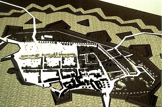
Theme map showing area's of different character.
Even in a town as small as Heusden one finds areas distinct in
character. We can distinguish the following:
In the three-dimensional models the different characteristics of
these areas become visible but not convincingly from a distance.
In order to make the computer images better understandable, the
above-mentioned areas have been given different colors, thus
linking up with thematic cartography as we saw in the
visualization of the Development Plan in Chapter II. A theme-map
is in fact very close to the function maps attached to the
Development Plan. The function maps consist of a ground plan in
which different functions, distribution of elements, etc. are
indicated per map. Whenever possible, this traditional way of
two-dimensional representation should be followed. This is an
example of where the use of computer does not necessarily add a
special quality or affect the results. However, when the theme-maps are displayed in three-dimensions they can add the third
dimension since the indicated objects can be seen
in projection in their surroundings (cf. a wooden model with
lights which can be switched on). This makes them easier to
compare.
Another problem arose with the description of the morphology of
the town block. We had decided at the beginning of this project
not to visualize the houses within the town blocks, because
neither Jantzen (1943) nor Peetoom (1965) went further, at least
in their drawings, than the interpretation of the street walls.
This was also true of the instruments of the protected
townscapes. However, from what we saw in Chapter IV,
Peetoom did indeed consider the interior of the building blocks.
The re-allocation of the gardens, the subtle location of the
garages, and the fencing-off of properties by low brick walls
bear witness to that (Figures 130 and 138). Since this
information is lacking in our computer models, the morphology can only be described in general terms. For a more detailed analysis
these spatial elements should be considered in following
projects. Essentially the same difficulty occurred with respect
to our decision not to visualize the relief of the land. Despite
the fact that in this project our attention was mainly
concentrated on the changes and continuities of the plan, the
volumes and the façade detailing, it appeared in the
course of the project that the relief was very important.
Although The Netherlands do not have much relief, the small
differences in height, caused by the rivers, sewers, drainage
channels, dikes, and fortifications turn out to be fundamental
in determining the way changes occur.
The color distinction of the brick (grey) and the plastered or
painted houses (white) in the computer images was useful in
allowing detection of the extent to which façades had been
deplastered. It was also very effective in simulating a dynamic
view of the street walls. At the same time, the computerized
façades preserved their abstract nature, which allowed us
to compare them at the same level of detail. Being able to order
and combine information can help the researcher tremendously.
Increase or decrease of scale, the changing structure of the
townscape, the distribution of urban elements, all can be clearly
illustrated by means of these models seen from the same
viewpoint. In fact, the models convey their own visual story of
how the town changed through time.
The first real change of urban scale took place only after the
Second World War. The rows of council housing near Burchtterrein
from the reconstruction period meant a change in the typological
scale of Heusden. Although the houses have
traditional saddleback roofs, there is very little
variation in the exterior: they are a repetition of rather
functional dwelling units. These rows of houses impose their own
form, independent of the existing urban form.
Some post-war apartment buildings (Pelsestraat 1-3,
Drietrompetterstraat, Putterstraat, Molenstraat) introduced a
scaling-up of the street walls. Because the apartment building
on Pelsestraat is almost twice as high as the houses that used
to be on that spot, the Catharijne Church is no longer visible
from Putterstraat. The view is completely blocked
by the new building. The rows of buildings at
Drietrompetterstraat and Putterstraat are less obtrusive, but
since they replace a series of individual houses, their
repetitive character introduces a horizontal scaling-up of
dimensions and more monotony. These apartment buildings generally
followed the existing alignment, except for the building in
Molenstraat which was set back from the street. The apartment
building in Molenstraat consists of maisonnettes with garages at
ground-level and the living room on the second floor overlooking
the fortifications and the Meuse River. At the end of the
fifties, this type of apartment building was considered the ideal
solution to increase the building density. If it had been
realized, the Redevelopment Plan (1961) (Figures 41 and 42) would
have meant scaling-up and a serious break with the existing urban structure, since it envisaged surrounding the town by this kind
of high-rise building. The inner town would then
have had three major barriers: the town would have been
surrounded first of all by water, secondly by the reconstructed
fortifications, and thirdly by the ring of highrise blocks and
rows on the outskirts of town overlooking the fortifications.
The 1965 Development Plan proposed the opposite of the
redevelopment policy: repairing and improving the urban fabric.
But the building typology based on the Development Plan also
meant a discontinuity of the building process, because it
proposed an artificial scaling-down. The scale was deliberately
kept small, sometimes, in fact, smaller than the minimum
according to the regulations. The effects therefore contrasted
strongly with current standards.
Peetoom's inserted dwellings may be seen as an example of making
use of existing local typologies. They are simple,
single-story houses with a living room and a kitchen downstairs,
and two small bedrooms and a bathroom upstairs. Peetoom designed
ten different types of these inserted dwellings, whose dimensions
were further adapted to the location. As a building type they
follow the 19th-century workmen's houses (as can be seen on many
turn of the century postcards) rather than any other (older)
existing type in Heusden. The effect of these inserted dwellings
(about fifty of them) was to scale down the town. Other community
project dwellings were built chiefly in the 1980's by the local
Housing Associations and are mostly located in the area south-east of Putterstraat and Ridderstraat. These have the same scale
and proportions as the inserted dwellings. Their scale and
dimensions were thought to be more appropriate into the secondary
streets than those of the higher 18th-century houses in
Breestraat. Only one of Peetoom's ten types of inserted dwellings
had a ground floor and two floors above, and this type was indeed
inserted in Breestraat where the houses are higher.
The complete restoration was in fact a planning intervention on
as grand a scale as the implementation of the Redevelopment Plan
would have been. The difference was the form in which it was
carried out - adapted style architecture, tending
strongly towards old forms in brick from the 17th
and 18th century. The advantage was that the accumulated
knowledge of the complete area enabled the architect, Peetoom,
to take many aspects into consideration and react to each
specific area appropriately. The disadvantage was that it perhaps
created too much unity, and sometimes distroyed the chronological
progression, since genuine contemporary design is absent.
However, the changes that actually took place in Heusden were not
large changes, but rather many subtle modifications in the urban
structure (the exceptions being the restoration of the
fortifications and the Town Harbor, the reconstruction of town
gates, and towers). It is the subtle modifications, however, that
to a great extent have determined the present appearance of the
townscape. Detailed knowledge of its history in the widest sense,
in particular the spatial form and function of the existing city,
can apparently lead to a reinterpretation of this history in
future designs for the city.
5.4 The Dynamics of Urban Transformation
In Chapter III, we traced the development of the urban structure
of Heusden from its foundation until the beginning of this
century by means of cartographic research. At all times, the
ground plan and the city's physical geographical structure served
as the starting points for the analysis of the urban
structure22. In Chapter IV, which zoomed in on developments in
the 20th century, the evidence used to trace the transformation
over time consisted of the analysis of the plan, the volumes and
the detailing of the façades. In addition, the effects of
local government decisions, building regulations, and
restorations (considered both chronologically and by architect)
were surveyed. The effects of local government decisions on the
appearance of the townscape were examined in more detail in
previous sections by focusing on the classification of the
buildings and on the elements and morphology of the town.
Nevertheless, certain questions remain to be answered. In the
following paragraphs we shall try to trace the process of change
and continuity in Heusden by reading the three-dimensional
computer models which represent the development over time
supplemented by older maps. The question of what image the town
wanted to propagate at different periods of time and how this was
reflected in the appearance of the townscape will be assessed.
The town's own history and the dynamics represented in the built
and unbuilt plans will also be considered.
So far, we have mainly dealt with changes and discontinuities in
Heusden. These are always more easily discernable than those
things which remain unchanged and have a more permanent
character. Despite many wars, raids, fires, etc., some areas or
structures remained relatively undisturbed and apparently
resistant to intervention.
- Geographical situation
- Fortifications
Until 1904, the fortifications and the Town Harbor provided the
enclosure on the waterfront. From 1904 to 1972, Putterstraat and
Waterpoort were dead-end streets, without no focal point at the
ends other than for a few trees on the leveled fortifications.
There were no clear boundaries near the waterfront. After 1972,
the new harbor and the reconstructed platform once more enclosed
the town, and the town gates and the Veer Poort became landmarks
again at the entrances to the town.
- General urban street pattern and structure
- Burchtterrein
- Boundaries of premises
- System of pathways through the town
Town block Vismarkt, Engstraat and Botermarkt in 1900, 1965 and 1990.
The image of the town of Heusden
After the discussion of the previous paragraph, we can now
consider the question of what image the town wanted
to present at different periods and how this was reflected in the
appearance of the townscape.
The loss of its function as a garrison town and the absence of
any economic prosperity in the 19th and early 20th centuries were
the reasons that Heusden no longer possessed any real identity
until after the Second World War. The town was still living on
its past fame as an invincible fortress town, as described by Van
Oudenhoven24. This historical awareness was only translated into
policy in 1964, after the idea of making Heusden a
modern town was abandoned. The only way to make the
town attractive again was to reinforce the visual qualities of
the old fortified town, which were at that time hidden.
The establishment of the self-image of the town, proposed in the
Development Plan, was the first evidence of historical reference
to the memory of Heusden's glorious past. In this light, it is
not surprising that cartographic maps by Van Deventer, Boxhorn
and Blaeu in particular, as well as some 17th and 18th-century
views of Heusden, were often referred to.
Although Peetoom surveyed the complete town, carried out
historical research, used available maps, and restored the town
to the best of his knowledge, the impression remains that the
visual material available at the time was very important for the
way the town looks now. Forms that once existed at a certain
place have in several cases returned. Which form returned,
however, apparently depended on what visual material was
available. In the first place, traces found in the building itself, and maps, photos, written descriptions, etc., but also
events from the past and the memories of the inhabitants. The
computer images of the street walls show that the collection of
photographs taken around the turn of the century were used to a
great extent during the restoration period25. At the time when
some buildings from the 19th and early 20th centuries were
demolished because they were considered incongruous, many of the
simpler houses were restored on the basis of these photographs.
Both the available visual sources and the collective memory
of the town appear to have been important. Rather than
inventing new forms, the architectural forms were borrowed from
what was known of its past. In this sense, the inserted
dwellings reveal something of the memory of the
place in abstract form and in their reinterpretation of
the scale and dimensions of existing local building types. The
thread of the town's own history with forms from the past was
picked up again and reinforced. However, Peetoom could not have
based his types on Blaeu's map, since, as we saw in Chapter III,
Blaeu had used a functional abstraction in
representing the façades which was far too coarse to allow
any detailed information to be derived from it. We may speak
here, rather, of an intuitive pragmatic approach to
the urban structure by Peetoom. Rather than carry out a rational
abstraction, as most of his contemporaries would have done,
Peetoom choose the more modest, contextual treatment of implicit
types, thus linking up with the traditional building trade.
The Dutch situation was therefore unlike Fortier's
bibliothèque des projets and one can rather
speak of a pragmatic application of conventional local types26.
As mentioned before, there are very few real monumental buildings
in The Netherlands which show a strong influence of authority.
Unlike the imaginary projects of Paris, which are of a different
scale and order, in Heusden, forms from the past were taken as
an opportunity to reinterpret in a pragmatic way. In this sense,
the individual façades forming the street walls have in
fact been the texture library of the research
project.
>From a distance, as in the 17th and 18th century view on the
town, the skyline is now characterized by the spires (Roman
Catholic Church, Town Hall, Catharijne Church) and by the
buildings gradually decreasing in height from the center towards
the fortifications, with accents at the end of streets (gates,
towers). However, more than those spires and towers, Lynch's way
of path finding via landmarks is
nowadays taken over by the cranes near the shipyard, which, being
higher than any other building in the neighborhood, indicate
where the town of Heusden can be found. Since the fortifications
were reconstructed 1.5 meters lower than they used to be, and the
houses are nowadays higher than they were in the 17th century,
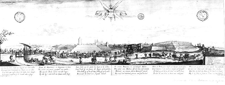
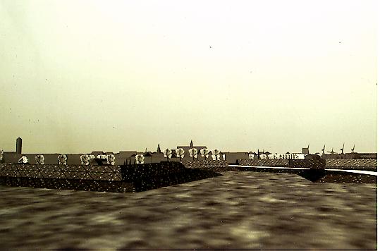
much more of the roofs can be seen from a distance than the map by Matham (1625), for example, shows us.
View of Heusden by Th. Matham, Atlas van Stolk, Rotterdam 1925.
Computer image, comparison with Matham's view.
The aesthetic qualities of the almost symmetrically laid out
fortifications can only be seen from the air. Just as Naarden's
fortifications were restored as a historical example of the New-Dutch Fortification System (Menno van Coehoorn) showing the
intimacy and compact character of a Dutch town27, so represent
the restored fortifications of Heusden the historical example of
the Old-Dutch Fortification System.
An artist's impression made in 1974 still sells very
well at the local tourist information center. The map appears
strongly influenced by Blaeu. Although the spatial form of the
town has been represented relatively accurately, many individual
houses appear even more standardized than in Blaeu's map. In
addition, the Catharijne Church is felt to be complete again. The
self image which the local government wanted to
propagate can be read in this kind of town plans. The 1974 plan
in particular does not show a living urban community, but a
rather a dull, sleeping, still agricultural town where the
buildings are much more picturesque and less
urban in scale and character than they are in
reality.
The idea of the city, its alternative possibilities
as in Rossi's analogous city, can be compared with
Heusden as a 17th century regional center, where merchants and
ships came and went, and strong fortifications protect the
inhabitants against raids. The town was unable to regain its
fortress function in the 20th century, so the only alternative
was sought in the rudimentary present qualities which were turned
into opportunities: the structure of the town and its scenic
collage of styles, and tourism would be exploited for recreation
and watersports. The intention was never really to bring
back the past in Heusden, which would be impossible
anyway, since we would experience it with our knowledge of today.
It was rather to borrow forms from the past in order to improve
the present and guarantee the continued existence of urban
qualities. In this sense, the use of the map by Blaeu turned out
to be an important political instrument for convincing the
authorities of Heusden's potential. The restored image of the
prosperous 17th or 18th century as seen in Blaeu's map created
a new function for the town: tourism and watersports. Thus, a
historic town became an attractive place to relax and escape from
citylife. Baalman points out that there is an important market
for historic towns: `reconstructions like Heusden or
villages frozen in time like Orvelte function optimally during
the holiday period. Their attraction is not due to the activities
of daily life, but to the attractive decor they offer for
holidays, rest and recreation'28.
People tend to think more in images nowadays. They have developed a taste for fast-changing images which Virilio calls
Dromology. But, this should not lead to a purely
scenic architecture, as in Venturi's decorated shed
architecture. In this sense, Van der Woud's
strategic preservation of monuments of the image of
the city by means of scenic and specialistic major monuments is
therefore not a good starting point, since the scenic approach
would destroy not only the documentary value of the underlying
historical structure and of the buildings themselves, but also
the continuity in time and regional variations. Panerai adds to
this: Restoration should not lead to the establishment of
museums, or pieces of tasteful Disneyland for the benefit of
tourism; nor the systematic restoration of small houses in
their original state, because it would be against
the logic of domestic types of urban building in which the lower
front functions relatively independently from the rest of the
façade29.
The fact that exploitation of the architecture of the past can
be a lucrative business also becomes clear from the almost
finished Huis ten Bosch, a newly built Dutch
Town in Japan30. While in Heusden the return of the three
replica postmills near the waterfront and the re-excavation of
the Town Harbor were the object of much criticism, the Japanese
have no trouble in embellishing their invented Dutch town with
replicas of the replicas of Heusden's postmills. In Japan they
even prove that it is actually possible to re-create an imaginary
Dutch town in which the fronts, in the style of Heusden after its
restoration, have no relation at all with the interior. The
statement that the scenic image of the city is the one-dimensional implementation of the protected townscape can
well be applied to this scenic Dutch architecture as executed in
Japan, however, it cannot be applied to Heusden31. The image in
Heusden was to a certain extent aimed at the improvement of the
townscape as a whole but it was also based on historical visual
evidence, using its own history and form.
Although the replacement of the old Town Hall by a new one with
a public square on its site meant a severe structural change at
the very heart of the town, it proved that the former Town Hall
was not solely responsible for the identity of Heusden. A sudden
disaster such as the destruction of this former structurally and
visually important monument shows that indeed the basic street
structure and the material of the town, i.e. the
many small buildings, are more important than a single monument.
A town can apparently deal with the loss of even important
monuments in a flexible way. New forms can emerge without
destroying the soul of the town - its street pattern
and structure. An imaginary example is the town of Makor, as
described by James Michener32. Each time the town of Makor was
destroyed againfromon its ruins emerged other cities or histories
built on top of each other, each town higher than its
predecessor. People, conventions, religions, and circumstances
may change but each different period builds on its predecessor,
handing over fragments from the past to be used as a source for
future design.
The typology which allowed us to make various combinations with
the texture maps of the façades showed that most listed
17th-century buildings were radicaly restored to their former
appearances, whereas most 18th-century and a great part of 19th-century façades were not radically changed. In general,
buildings received late 18th-century mullioned windows. In order
to detect this kind of pattern, time-series appear very useful
and are also verifiable by others.
The morphological changes were studied by means of analysis of
the elements of the urban structure in the computer models. It
appeared that areas different in character could be
distinguished, which were treated as such, at least by Peetoom,
during the restoration period. Increase in the density of the
urban structure occurred with consideration for each
specific location. The many small changes in
relatively short periods of time in the 20th century have to some
extent led to a metamorphosis of the town, caused not least by
the new accents at the ends of streets. The visualization of the
morphology in the three-dimensional models was very useful in
analyzing the silhouette of the town and, close-up, the changes
at specific areas in the town. But the models do not make clear
what changed between each phase. One solution is to emphasize the
changed element per image by using different colors. In this way,
the computer images can themselves show the development.
In the final section the dynamic currents of the town and its
image were explored. As always, the development
continues by fits and starts, but in some places, such as
Heusden, this means many events in a relatively short period
(c.1700 and after 1944) alternating with long periods of no
change at all.
The other city of Heusden, the Redevelopment Plan,
is still invisibly present in Heusden, as an argument and excuse
for the costly restoration. Now that the structure of the town
has been repaired, maybe some well-designed contemporary
buildings will emerge.
Notes:
1. Meischke & Zantkuijl 1969.
2. Dolfin et al. 1989, xxiv-xxv. 3. Unfortunately not the exact dates of the buildings were mentioned, but by spaces of time of 25 years. To provide a much more accurate list of
dates was out of the scope of this study.
4. Kool-Blokland mentions the fact that even the (former) elite in Heusden rather invested their money in premises and real estate than in luxury
and decoration of their houses. Kool-Blokland 1985.
5. An arrangement of the facades of 2-2-1 means: a house consisting of two bays. The ground floor probably consists of one door and one
window, there is one storey above the ground floor with two windows and one storey or loft with one window. The other arrangements can be
interpreted in the same way. Van der Vaart 1985, 2.
6. H. Janse carried out building construction analysis of buildings in Heusden in the nineteen seventies. The results were never published but can
be found at the Rijksdienst voor de Monumentenzorg, Zeist. Janse 1986.
7. A Dordtse gable is a local type of gable named after the town of Dordrecht. Characteristic features are the projecting courses on the first and
second floors, often on sculptured headers, and basket handle arches above the windows. Temminck Groll (1963, 73) mentions the fact that
the Dordtse gable of Putterstraat 1a, built in 1521, is even older than any Dordtse gable surviving in Dordrecht itself.
8. Van der Vaart 1985.
9. CF. Apell 1988.
10. In Dutch: Gebosseerde gevels.
11. See also Chapter IV, 4.3.
12. Perhaps the "Monumenten Inventarisatie Project" (MIP), a project which is investigating the historic buildings of 1850-1940, may change this.
13. De Boer 1984, 19.
14. Meischke 1988B, 208-253.
15. Meischke 1990.
16. Meischke 1990, 9-20.
17. See, Appendix I.
18. Peetoom 1980, 24.
19. Ben de Vries 1990, 50, calls this type of public place a "street market-place" (straatplein) characteristic for some castle-towns with a planned
urban lay-out.
20. I do not agree with Ben De Vries 1990, who argues that the Fishmarket is also a widened street.
21. When many of the fortifications were dismantled in the nineteenth century, they were generally neglected for a long time. From the nineteen
twenties onward, a renewed interest in the preservation of former fortifications sprang up for recreational and tourism purposes. Cf.
Schukking 1988.
22. Cf. Fortier's "archeologie inverse".
23. Cf. Braudel 1949.
24. Van Oudenhoven 1651.
25. See, for collections of postcards: Harry Poll 1969, collection Chr. Lith, and collection Streekarchief.
26. Cf. Bandini 1984.
27. Mumford 1964, plate 49.
28. Baalman 1989, 29-32. In this sense De Jong distinguishes different kinds of "preservation of Monuments", one involves the "touristic
alternative". De Jong 1992, 71-73.
29. Panerai 1981, 20.
30. Paul Meurs 1992.
31. Taverne 1989, 15. 32. James Michener, The Source, New York 1965.
5.1 Introduction
5.2 Global Analysis of Façades
Since this project deals with the exterior of buildings,
Meischke's typological system (discussed in Chapter I), which is
based on the architectural analysis of buildings and on the
interior division of dwellings, cannot be applied here1.
Instead, we made, to some extent, use of the typological method
used in the Geïllustreerde Beschrijving
(Illustrated Description) of the houses of Utrecht in which the
volume of the buildings and the orientation of the roofs are
taken as a basis. In contrast to the starting point of that
study, which was to describe only listed buildings, we included
all buildings encountered in the area of interest2.
The main functions of buildings to be found along the streets
are: dwellings, shops with dwellings above, warehouses, and town
farms.
Some interesting 17th-century Dutch gable types can still be
found in Heusden; For example, the stepped gable of Vismarkt 1
(now a restaurant and hotel), the shaped gable of Hoogstraat 4,
or the pilastered façade of Vismarkt 7 (both residential
buildings again).
18th-century gables mainly comprise simple bell gables and
truncated scrolled gables. It is striking that, apart from some
replacements of 19th century T-shaped windows by late 18th-century sash windows (2x3), few changes took place in the
façades. The many relatively simple cornice-façades, which are sometimes in brick and sometimes
embossed10, have almost all been retained intact. The T-shaped
windows dating from the end of the 19th century of a rather large
mansion (built in 1760) (Wijksestraat 38) were replaced
by the original 18th-century sash windows, while the front door
(from 1845) was left as it was. It turned out that, even when the
original (i.e., older) appearance of buildings was known, the
existing façades were mostly preserved (Breestraat 25).
The listed buildings of the 19th century show a variety of types
of architecture and functions, including warehouses, simple
mansions and shops. Here again, with the exception of Vismarkt
4, all plastered façades were preserved. Only a few
examples of Neo-Gothic architecture (Botermarkt 3) and
façades with windows enclosed in architraves (Botermarkt
1,8) are listed. The special type of 19th-century windows with
arched glazing bars in the upper parts (Vismarkt 2 and
Wijksestraat 19) were partially replaced by a more current type
of window, i.e. the sash window, divided into six lights.
- 20th century
None of the pre-war buildings have yet been listed12. As
mentioned in Chapter IV, a few Jugendstil buildings were
demolished near the Town Harbor. The Jugendstil buildings were
generally preserved, although some Jugendstil windows were
replaced by 2x3 windows. Some examples of the Amsterdam School
can be found scattered over town. These buildings are built in
brick, sometimes also with decoration in brick and they usually
have flat roofs and rather small windows. Though plans were drawn
up during the restoration period to replace them with more
traditional houses or at least provide the buildings with pointed
roofs, they were not put into effect. Post-war constructions
appeared to be in such a good condition that they needed no
restoration. New buildings and inserted dwellings were built by
the Heusden Housing Foundation in adapted style in
brick and often supplemented with a cornice and mullioned
windows.
View to the Town Hall in 1990.
1. Botermarkt, Hoogstraat, Waterpoort, Engstraat and Vismarkt,
are characterized by relatively high, narrow, deep plots. The shopping area is situated in these streets as well as the tourist zone, with souvenirshops, workshops and
cafés.
2. Putterstraat is a typical back street with
various kinds of buildings, mostly residential, which are usually
lower in height than buildings in the main street.
There are as many deep buildings as transversal ones and
consequently the width of the plots varies.
3. The area near the former castle, Burchtterrein, is marked by
open rows of houses from the reconstruction period which have no
relation to the former urban texture.
4. The complete fortifications and the waterfront in particular
(Town Harbor, marina) is a recreation area21. The
consolidated castle ruins, the Baroque garden of the
Governor's House and the area near the Catharijne Church are also
part of the recreation area.
5. The area south-east of the Demer Canal is characterized by
urban renewal social housing dating mainly from the second
restoration period, with low rows of houses in adapted
style and light red brick.
In general, it is believed that the geographical situation of a
town changes only gradually23. However, from the old maps of the
river area near Heusden, it appears that the area, on the
contrary, has been very flexible in form. The many diversions
caused by natural inundations over many centuries (for example,
`St. Elisabeth's Food' of 1491) as well as deliberate changes
(the cutting of the meanders in the Meuse River in 1479 and
later) prove this. In fact, during the 20th century, the town
came to be situated further and further from the river. First,
when the new estuary was dug, the Town Harbor was filled in in
1904; and the land around the town silted up, creating a greater
distance between the town and the water. In
this period (1904-1965), the town seemed to turn away from the
water, directing its focus more inward to its own center. As soon
as the fortifications near the waterfront were restored and the Town Harbor re-excavated, the town regained some of its open
character, once more oriented towards the water. But now, the new
marina and the three fingers of land have screened the town off
more from the river.
Over the centuries, Heusden's fortifications have not only
withstood many attacks by armies but also, more recently, the
onslaughts of bulldozers. After the official dismantling in 1816
and the final departure of the garrison in 1879, the
fortifications were no longer maintained. However, though without
a defensive function, they survived, mainly as agricultural land,
virtually intact. The geographical distance between the built-up
area within the fortifications and the countryside beyond thus
remained. It was mere lack of money that
prevented drastic building activities. The many attempts between
1932 and 1965 to get permission to level the fortifications were
not approved by the government.
The most striking continuity in the town is the complete
stabilization of the urban street pattern and structure since the
construction of the second bastioned fortifications in 1613. Even
the older lay-out as seen in Van Deventer's map (c.1560) can
still be easily distinguished. In later centuries, there were
hardly any changes until after the Second World War when
Burchtterrein was partly built upon. The laying down of a new
street connecting the Oudheusdense Poort with the Demer Canal
during the restoration was the only serious cut in the existing
texture. Further, the Demer Canal was partly restored in 1922,
only to silt up again and be re-excavated and completed during
the last phase of the restoration period. But these were only
small changes in the urban structure. What is remarkable is that
the medieval town plan still survives, regulations about
alignment, building heights, and width of the façades
having been followed to a modest degree.
It is striking that the area near the former castle has never
been built upon since the destruction of the castle itself in
1680. Though the ruins of the castle were only cleared away in
1824, and only one tower continued to be used as a place for
storing gunpowder, the area was never built upon. Since the area
was probably military property, it is possible that, for a long
time, no building on the terrain was allowed. To judge from some
old postcards, the terrain was at times used for military
exercises. It seems that this area has always resisted being
built upon. This is also shown by the failure of the
Reconstruction Plans.
As was mentioned above, the system of drainage determined, to a
great extent and for a very long time, the boundaries of
properties and the width of the façades.
Also relevant to the boundaries of premises are the
informal or private pathways through
the town. These can be seen on the map by Blaeu. The wider
eavesdrops at Vismarkt, for example, are turned into small alleys
connecting Vismarkt with Botermarkt. There were also pathways
leading from the major streets to the fortifications and the
sorties, the escape routes under the walls of the
fortifications. Maps show that this system has stayed virtually
intact despite the delapidation of the fortifications and new
buildings inside the town blocks. During the restoration period,
the clear boundaries between premises were restored by building
1.8-meters-high-walls. Many pathways now connect streets with the
backyards of the houses, forming again a semi-private route.