Architectural Design and visualization techniques.
A case study: Heusden.
Patricia Alkhoven
|
Architectural Design and visualization techniques. A case study: Heusden.
Patricia Alkhoven |
Chapter IV. Heusden: Urban Development 1900-1990; Plans and Realizations
4.3 Development 1946-1965, the Reconstruction
4.4 Development 1965-1990, the Restoration
4.5 The Management of Heusden's Townscape
Heusden's development before 1900 having been dealt with in the previous chapter, the present chapter focuses on the spatial development of the town in the 20th century. The emphasis has been laid on events or historical aspects and situations that have directly influenced the history of the town and that have led to plans being drawn up. These plans and their realizations, supplemented with information from archives and literature, were interpreted in the present study as the reflection of management decisions and the building process affecting the townscape.
As discussed in Chapter II (2.3), three-dimensional computer models were made for the six reference dates in the 20th century (1900, 1943, 1946, 1965, 1975, and 1990). From each of these reference dates the changes in the ground plan, the building masses and the façades were visualized. Since any viewpoint in a three-dimensional model shows only part of the façades, it is difficult to analyse the transformation of the façades. In order to solve this problem, the façades were detached from their three-dimensional house-volumes. So, apart from making the development over time visible through three-dimensional models showing the buildings in their spatial context, the texture maps of the façades are shown detached from the three-dimensional house volumes. In this way, the façades forming the street walls seen in elevation were formed. When the six street walls are displayed in a single image, the often subtle changes in the façades can be read from top to bottom. It should be noted, though, that these images still need to be interpreted and that the computer does not tell us what has been changed. These computer images were needed to be able to analyze, among other things, the approaches to restoration, which will be discussed in more detail in 4.3.
The same texture maps were used to explore the influence of some of the architects as implementors of a certain policy - how this policy was realized in the townscape and to what extent the architects chosen were responsible for changing the appearance of the town. The computer images demonstrate the restored houses ordered by the architects more or less in chronological order of their restoration. The models are referred to in the text but since they mainly serve as illustrations to this chapter they are not further explaned here.
The chapter is divided into four sections. The first three describe Heusden's development in the 20th century more or less chronologically. First, after a brief overview of the plans and realizations between 1900-1945, the development after 1945 is dealt with rather extensively since several plans, all different in character, were implemented in Heusden within a relatively short period of time. The second section deals with the reconstruction period from 1945-1965, and the third section assesses the restoration of Heusden which took place from 1965 to 1990. The final section discusses the management of the townscape with respect to national trends in urban planning, the influence of local government and the different approaches to restoration as seen in Heusden.
Around the turn of the century, the economic climate in Heusden was far from favorable1. Some gradual - though rather late - industrial development from small trade to the establishment of several small industries in the second half of the 19th century, had not solved all of Heusden's unemployment problems, since no real new ways of becoming an attractive center had been explored. These small industries were often built in between dwellings or in the gardens inside the blocks2. Heusden was almost completely self-supporting, with a small elite who owned the factories employing their fellow citizens. The factory owners were often members of the town council and they could resist new enterprises which would affect their own profit. In this way they often prevented new developments3.
The loss of its primary function as a fortification town in the 19th century, and the final departure of the garrison in 1879 was a severe blow to Heusden's economy. The tradesmen had to a large extent geared their businesses to serving the approximately 100 men permanently stationed at in the garrison and the many troops who lived there on a temporary basis4. After the garrison left, the many small tradeshops could hardly make a decent living in a town of about 1850 inhabitants5. The rapid growth of the neighboring town of 's-Hertogenbosch caused Heusden to lose its function as a regional center, since, with improved transportation and better roads, the villages in the neighborhood were no longer dependent on Heusden for their supplies. Although some products were still delivered by dog cart to the surrounding area, local government did not stimulate a new function for Heusden. As a consequence, the town became impoverished. Due to lack of funds, the repair and maintenance of buildings was neglected.
At the turn of the century, the main public buildings in Heusden were the Town Hall, the Catharijne Church, the Fishmarket Hall and the Roman Catholic Church (built in Roomse Kerkstraat in 1841). The Town Hall was originally built in 1588 after the earlier one (dating from 1461) was destroyed by the great town fire in 1572. In 1635 it was extended with a tribunal, and radically restored in 1876-1880 by J. Gosschalk6. The tower, which was in bad repair, was restored7 at that time in the style of the building. The entrance was removed to Breestraat. The Town Hall was built to a rectangular ground plan in red brick banded with stone. The front was three bays wide and the side elevation was five bays wide flanked by small pinnacle-towers. Above the ground floor were two stories. Above the front was a tower with carrillon and there were dormers on the roof. The Town Hall and its tower, situated on the corner of Breestraat and Pelsestraat, dominated the town center. It was destroyed during the Second World War and rebuilt in a different form in 1955.
Behind the Town Hall we find the Catharijne Church8, a pseudo-basilica, which was probably built in the thirteenth century in the style of the Kempense Gotiek9. It was extended with a transept in 1555. The church was destroyed by the town fire in 1572 after which the nave was rebuilt. A new choir was built in 1637-1640. Around 1900, the church consisted of a nave with five bays with a singular south aisle and a north transept with double aisle. The church is vaulted with a transversal barrel vaulted wagon ceiling10. Above the west door there was a truncated tower (the spire was removed in 1811). It was destroyed in 1944. The church has a saddleback roof and was built in brick banded with stone, thus forming a unity in appearance with the neighboring Town Hall.
The Fishmarket Hall (1796) replaced an earlier hall built in 1639 and is the only surviving public building in The Netherlands which dates from the period of the Batavian Republic (1795-1806). The Fishmarket Hall has the form of an open gallery with two wings at right angles to it. Twelve free-standing hard-stone doric columns support a wooden architrave decorated with triglyphs. In the rear wall are three open-arched windows looking onto the Town Harbor.
The Preliminary List of Monuments (1931) mentions the fortifications, the Town Hall, the Fishmarket Hall, the St. Jorisdoelen (Putterstraat), the Catharijne Church, the Roman Catholic Church (1841), twenty houses and some street furniture and architectural details11. The twenty provisionally listed houses are Hoogstraat 1, 4; Putterstraat (corner of Pelsestraat); Ridderstraat 5 and 7; Oudheusdens Eind W9, W29 and W32; Engstraat 8 and 6; Wijksestraat 8; Vismarkt 1, 7, 14; Drietrompetterstraat 18; Waterpoort 1a; Breestraat 10 and 10a; Stadshaven 24. Only two "later façades", i.e. façades built after 1700, were listed in 1931: Pelsestraat (4/6) 11/13 and Wijksestraat 38. It is striking that, with the exception of Wijksestraat 38 (which probably thanks its listing to its excessive decoration), none of the many interesting 18th and 19th century buildings with straight cornices were listed in 1931. In accordance with the preferences of the time, buildings from the 16th and 17th centuries, in particular those with stepped or scrolled gables, were apparently favored.
A new economic chance for Heusden came when the new estuary of the Meuse River was dug. Heusden's position on a dead end of the Meuse River since 1479 was not very favorable for trade. In 1883 a plan for the new estuary was approved. The new estuary, which was officially opened by Queen Wilhelmina in 1904, meant that Heusden was again situated directly on the Meuse River12. The old Town Harbor was filled in and turned into public gardens and renamed Wilhelminaplein. Ships would load and unload at the new quay, near Wilhelminaplein. The new harbor was moved to the north-east side of town. Heusden's more favorable position attracted new trade. An important development for Heusden was the foundation in 1905 of a shipyard (De Haan & Oerlemans, later: Verolme) on the Hollandia Bastion and the establishment of a canning factory (Jonker Fris) outside the Wijkse Poort (1910). These industries became the most important employers for the citizens of Heusden. Except for the Hollandia Bastion, the fortifications were virtually left intact, with the two industrial companies at the entrances to the town, protecting the town from expansion.
Nevertheless, during this period the town also began to be opened up to its surroundings. The Wijkse Poort was demolished to make way for the steam tram between Heusden-Drunen-'s-Hertogenbosch which breached the fortifications. The Wijkse Poort was the last gate to disappear as the Herptse Poort and Oudheusdense Poort had already been demolished sometime after 183213. The steam tram was discontinued in 1929. With the disappearance of the Town Harbor in 1904, the Rates House (Commiezenhuis) was also demolished. The Fishmarket Hall, however, was restored because it could be used as a park pavilion. Vismarkt and the new park became connected as a continuous open space. The windows in the rear were replaced by porches so that people could walk from Vismarkt through the Fishmarket Hall into the public gardens. The roof of the Fishmarket Hall was decorated with a small spire.
World War I brought an economic crisis everywhere in The Netherlands since there was a lack of almost everything. This also influenced building activities, which almost came to a halt. Demer Canal, which was still functioning as an open sewer, slowly became silted up. After plans for filling in the Canal were rejected, it was partly restored in 1922 and kept its function as the main sewer.
The façades of newly-built houses and building repairs mainly followed current fashions: between 1905 and 1920 some modest examples of Jugendstil façades and windows emerged (Stadshaven 10/11 and 12; Wijksestraat 4, 13/15, 9; Hoogstraat 1, 14, 17/19; Breestraat 6, 35; Engstraat 2, 13; Vismarkt 11; Botermarkt 5) and a rare example of a building in chalk-sandstone (c. 1906) Waterpoort 18. The new buildings often replaced delapidated buildings or were modernizations. Building activities hardly took place at all in Putterstraat, probably because many houses had only been built or remodeled in the second half of the 19th century and did not need changing.
After 1925, the appearance of buildings and façades became influenced by the Amsterdam School - though again only to a modest degree. Examples can be found at Vismarkt 13/15; Wijksestraat 44; Breestraat 37/39, Pelsestraat 6; Putterstraat 31 and Waterpoort 28. Many other houses underwent minor repairs before the Second World War, but these hardly had any impact on the appearance of the exterior since radical repairs and changes were postponed due to lack of money. The changes can best be seen in the replacement of window frames allowing larger panes of glass: T-windows and H-windows.
After 1930, the international depression was also felt in Heusden and slack business in the shipping trade caused a rise in unemployment. The town council tried hard to find projects for the unemployed. In this respect, plans for leveling the fortifications and filling them with reed lands turned up more than once between 1932-1938 but were prevented by the national government and the Stichting Menno van Coehoorn14. The responsibility for the former fortifications was delegated from the State to the Province in 193415. A year later an Extension Plan for south of the town was drafted. It was finally postponed, however, because of the threat of war.
General mobilization was proclaimed in August 1939. During the first years of the war, Heusden was not much affected. In 1943 a project for unemployment relief work for an Investigation of Dutch Urban Beauty was realized by a group of architects from Amsterdam headed by F. B. Jantzen16.
Town plan 1943, Ferd. B. Jantzen.
The building licenses that were issued between 1900 and 1940 do not indicate the building of large numbers of new houses or many remodelings17. Most building licenses were issued for the construction of small outbuildings within the blocks. In this way, several industries were started close to residential areas. Due to the neglect of maintenance in the 19th century, many houses had already been condemned in the first decades of this century, but people kept on living in them. Hardly any initiative came from local government for the building of new houses. The shipyard built almost 30 percent of the new workmen's houses at various places in the town. The rest of the building initiatives came from private individuals and small industries18.
The open spaces and gardens within the blocks became filled slowly with all kinds of small industries. It appeared that there was more terrain left for building south-west of the Demer Canal. These open spaces were partly occupied by new types of buildings, such as schools. These were usually larger in scale than individual dwellings. Some small blocks of workmen's houses were also built at several locations in the town.
On the night of 4/5 November 1944, the retreating German army blew up the Town Hall while over 200 people were hiding in its cellar. Almost 10% of the inhabitants perished in the war. The Roman Catholic Church, part of the Catharijne Church, the last remaining windmill, a Synagogue (1870) and many houses were also destroyed19. Continuous shelling during the following days destroyed many more houses20. Altogether, this meant the destruction of a great part of the town.
Since the second half of the 19th century, Heusden's economy had decreased significantly due to the fact that its rôle as a border town had come to an end. The change to the Meuse River in 1904 was Heusden's first expansion and it at least enabled ships to pass through the new estuary. It was only thanks to the shipyard and the canning factory situated just outside the town near the river that Heusden did not decline into a ghost town. The general picture before 1940 was one of increasing dilapidation of the existing building stock from lack of repair. The gardens inside the blocks were gradually filled in with small industries, houses, sheds, and many gardens were bought up by a few owners, leaving the other houses without a garden. On the positive side, however, some new houses were built or renovated in contemporary style: Jugendstil, Amsterdam School, and brick expressionism.
4.3 Development 1946-1965, the Reconstruction
As soon as the Second World War was over in 1945, the war damage in The Netherlands was assessed and plans for reconstruction were drawn up. However, in the first years following the liberation very little could be achieved. It became clear that economic recovery could only succeed if there was government intervention. Government intervention in the immediate post-war years involved the distribution of materials and subsidies. Reconstruction schemes drawn up by municipal or provincial planners were regulated in 1950 in the Wederopbouwwet (Reconstruction Act). Only under the Reconstruction Act, initiatives for and implementation of Reconstruction Plans were placed in the hands of the municipal authorities, after approval of these plans by the Ministry of Reconstruction and Housing. When the Marshall Help Plan provided means for industrialization and infrastructure, money became available for housing and town planning21.
All through the 19th century right up until after the end of the Second World War, poverty had probably saved the town from changing radically. But it was not only transformation that failed to occur - maintenance and necessary structural repairs had also not been carried out. There was not even any money for demolition. As a consequence, Heusden was a sorry sight in the early nineteen fifties and there was very little that seemed worth to retaining or restoring. In fact, the town had completely lost its soul. For the inhabitants, the loss of the Town Hall, which had so dominated the town, was especially hard to bear.
Heusden had already drafted an Extension Plan for south of the fortifications in the years before the war. After the war this plan was re-examined but the government would only grant financial help for rebuilding destroyed towns within the built-up area. From 1945 onward, plans for the Extension south of Heusden and a Reconstruction Plan for the area within the fortifications, including the partial restoration of the fortifications, were developed. The architect/urban designer N. van der Laan from 's-Hertogenbosch was chosen to draw up the Reconstruction Plan22.
The Reconstruction Plan of 1946 proposed maintaining and if possible improving or completing the existing urban structure23. The Plan contained an inventory of the buildings in the town and their state of repair. Of the 423 dwellings for 1751 inhabitants within the fortifications, 146 dwellings were found to be beyond repair. A war damage map shows the open spaces left by destroyed buildings. Among completely destroyed buildings or parts of buildings were the tower and two northern bays of the Catharijne Church, the Town Hall, neighboring middleclass houses on Pelsestraat, a Synagogue on Breestraat, a wind mill on the Oranje Bastion, the Roman Catholic Church and a number of houses24. Many other houses were badly damaged. The map shows how serious the situation was. There was hardly any building that did not need repair. There were 61 buildings that needed to be rebuilt: the Roman Catholic Church, the Town Hall, 27 dwellings, 13 council houses, barns and a farm. Some industries were removed to another place where there were fewer people living in the vicinity. Though the Reconstruction Plan stated that there was no space left within the fortifications for new buildings, some new houses were planned for near the Wiel, the Demer Canal and on Burchtterrein where the castle once stood.
Out of respect for the victims, it was decided that the Town Hall would not be rebuilt on the same site. Reconstruction of the Town Hall in its old form, which had become too small for housing all the departments of the administration of Heusden anyway, would also have been too expensive. Instead, the fact that buildings next to the old Town Hall had been destroyed made it possible to build a new monumental Town Hall, leaving room for a public square at Pelsestraat. In 1947 the architectural firm of N. van der Laan and W. Hansen was commissioned to design the new Town Hall25. The opening of the new Town Hall took place on September 11, 1956, in the presence of Queen Juliana. The new Town Hall has a long main building (33 x 9 m.). The entrance is facing the public square on Pelsestraat, the area left by the former Town Hall, so that this building could always be reconstructed later, if required. The new Town Hall is a monumental building, seven bays wide, each bay having two windows, a larger one situated above a smaller, both in a field of brick which is slightly sunken into the wall. The official entrance in the fifth bay can be reached by a double flight of stairs meeting on a common upper landing. Below this landing is the entrance for the administration department. A carillon mounted above the official entrance plays every hour. The building has a saddleback roof with small dormers. Next to the building is an almost free-standing tower of about 35 meters high with a clock26.
F. B. Jantzen who has an extensive oeuvre of churches to his name was given the commission for restoring the badly damaged Catharijne Church27. Reconstruction of the destroyed parts was unacceptable for financial reasons. Instead, a new west entrance was built in an adapted but contemporary style, thus preserving as much as possible of what was left of the church. The destroyed truncated tower, which had dominated the townscape for many decades, was not rebuilt. Its contours were made visible in the pavement. An elegant spire, a so-called dakruiter, replaced the tower at the intersection of the nave and north transept. Side entrances were re-opened but traces of former restorations were left visible in the south wall, telling the story of the church. In addition, a new Roman Catholic Church on Burchtterrein by N. van der Laan was to replace the destroyed Waterstaats church which had been built in Roomse Kerkstraat in 184128. The Reconstruction Plan also incorporated the restoration plan for the fortifications drafted by the Stichting Menno van Coehoorn.
The Reconstruction Plan was decided on by the Board of Reconstruction and Housing on January 11, 1950. Only a small part of the plan was realized. In the years following the war many more or less radical repairs were carried out, mostly within the Reconstruction Plan. New blocks of dwellings were built along the Demer Canal and the Wiel. On Burchtterrein, the new Roman Catholic Church was erected on the site of building that used to be the front part of the castle. Some of the gaps in the street walls were filled in with small blocks of houses (Putterstraat and Drietrompetterstraat). A new underground sewer system removed the function of the Demer Canal as an open sewer.
Hoogstraat 4, restored in 1952, was the first real restoration of a private house under the Reconstruction Plan29. The painted shop signs were removed and the B-windows on the groundfloor were replaced by six-light windows. Furthermore, the local authorities and the RDMZ both tried to preserve another delapidated building with a stepped gable at the corner Vismarkt-Nieuwstraat (1603)30. But as months and years went by nothing happened. Finally, the local authorities requested permission for demolition, which was eventually granted31.
Revisions of the Reconstruction Plan
During site-work on Burchtterrein for the new Roman Catholic Church, archaeological investigations were carried out by the Rijksdienst Oudheidkundig Bodemonderzoek (Government Service for Archaeological Research) by J.G.N. Renaud to search for remains of the old castle below ground level32. Nothing of the castle, which had dominated the town from the twelfth century until its destruction by lightning in 1680, was left above the ground level, its bricks having been re-used over the years for other buildings. During the archaeological investigation in 1949, remains of certain walls of the fortress were discovered as well as the foundations of the octagonal tower33. The discovery caused a revision of the Reconstruction Plan with respect to the new buildings projected on Burchtterrein34.
Second revision of the Reconstruction Plan, N. van der Laan, 1953.
The first revision of the Reconstruction Plan proposed, respecting the remains of the old castle, was to only erect buildings along the present J. van Brabantlaan, while the function of Burchtterrein itself would be public recreation. The Demer Canal was to be filled in from Schapenbrugstraat to the opening in the fortified wall. The town council reluctantly gave up plans to build dwellings on Burchtterrein, and they approved the first revision of the Reconstruction Plan June 3, 195035.
With the exception of some buildings planned along Johanna van Brabantlaan, the first revision was realized according to plan. However, during the time this plan was effective, the shipyard again advocated the dismantling of the fortifications for economic reasons. The shipyard argued that opening up the town was the only way to make room for new developments and new extensions which would economically be geared to the old center36. The Ministry of Education Culture and Science (OKW) rejected another request by the town council for the dismantlement of the fortifications to make way for new extensions. It was decided by the Government that the expansion of the town should take place within the framework of the Extension Plan, Oudheusden37.
A second revision of the Reconstruction Plan involved the building of six one-family houses on the small strip of land where the Demer Canal had been filled in near Burchtterrein. After a positive decision by the Ministry of Education Culture and Science (OKW) in January 1953 and the Ministry of Reconstruction and Housing on February 4, 1954, these six one-family houses were built, respecting the remains of the castle.
New buildings and restorations realized in the period of 1945-1956 can be characterized as mainstream traditional post-war buildings. From the traditional movement (Delft School), a separate movement was distinguished in the Bossche School in which the leading architect, Dom. H. van der Laan, advocated a traditional architecture based on religious and natural harmony38. The form of the early Christian and Romanesque basilica was very important in their early work and was applied both to town halls and churches. The Roman Catholic religion was strongly advocated in the south of The Netherlands and the ideas of the Delft/Bossche schools of architecture were quickly absorbed. The fact that Nico van der Laan was a brother of Dom. H. van der Laan explains much of the appearance of the architecture built in Heusden under the Reconstruction Plan. The new Roman Catholic Church is an early example of the Bossche School approach39. The building consists of a nave with two aisles built in brick. On the north-side, an octagonal chapel is connected to the aisle. Next to the basilica is an octagonal tower.
Some 62 municipal houses of the current Delft-School type were built. These blocks of row houses all have saddleback roofs with the ridges parallel to the street running the length of the block. Each house has a ground floor, a second story and a loft, usually with dormers. Each row contains four to seven repeated houses set back from the street with front and backyards, while between the rows there are green open spaces serving as playgrounds for the children. These typical row houses are anti-urban in character and, as such, they contrast with the houses in the oldest part of town.
In general, in the years after the war, the main approach was to execute the necessary repairs, to restore or, if necessary, to demolish and replace buildings. This pragmatic policy for resolving the immediate housing shortage was the reason that the main fabric of the street structure remained intact even though there were many gaps to fill in the street walls. It should be noted, that the replacement of destroyed houses by rows of houses and the new blocks near Burchtterrein meant an increase of scale and an impoverishment in its architectural appearance by repetition and lack of ornamentation. The building activities, in particular the new dwellings near Burchtterrein, the Wiel and the Demer Canal, caused an increase in the population (from 1,751 in 1947 to 1,955 in 1960) and the number of registered dwellings (from 423 in 1947 to 466 in 1960).
The Redevelopment Plan
The Redevelopment Plan involved the intensification of building, including high-rise buildings, in order to increase the number of inhabitants to about 3,400: the more inhabitants, the more business for the local shopkeepers. Contrary to ideas of the local council who proposed high-rise buildings and demolition of at least part of the fortifications, Van Mourik only wanted to go as far as three to four stories in height (9-11 meters high). These high-rise42 blocks were projected around the historical center: along the Demer Canal, Wijksestraat-Drietrompetterstraat-Stadshaven and between the Demer Canal (southside) and Oudheusdense-straat. The Demer Canal itself would be completely filled in to make space for traffic and parking along a public green strip of land. A new public square was projected south of Breestraat, while buildings of bad constructional quality would be demolished and the site redeveloped. The original width of the main parallel streets (Breestraat, Botermarkt, Hoogstraat, Waterpoort and Putterstraat) could still accommodate modern traffic. Streets or alleys that were too narrow would be widened (Engstraat, Zustersteeg). Most corners would be rounded off at the cost of the corner buildings in order to make traffic safer. A new road entering the town from the south was to be constructed cutting through two blocks and ending near the new square next to the Catharijne Church.
The Redevelopment Plan took careful account of the requests of the town council. At the time, the town council of Heusden existed mostly of local shopkeepers and tradesmen who would profit from opening up the town to motorized traffic. They explicitly requested an increase in the number of inhabitants in Heusden, who were to be housed in the high-rise buildings. At a time when several towns in The Netherlands were applying a tabula rasa redevelopment policy, this was also seen as the solution for Heusden to overcome its economic problems. Finally, subsidies had become available for slum clearance. Many buildings were scheduled to be demolished after expropriation but not all of them were indeed pulled down. Several buildings on Stadshaven, Breestraat, Waterpoort and Putterstraat and particularly houses in the alleys were demolished in the period 1955-1960. The Modernist approach of high-rise buildings situated in green spaces overlooking the fortifications and the Meuse River was chosen in order to try and revitalize Heusden. The realization of the proposed changes would, however, mean an enlargement of scale in Heusden, and the historical structure would be radically transformed.
In 1961 the temporary Redevelopment Plan was accepted by the town council43. As soon as the plan was made public, negative responses followed in the local and national press, both from the RDMZ and Bond Heemschut44. This strong criticism was directed against the enlarged scale of the new buildings. Those who criticized the plan pleaded for the preservation of the historical structure of the town and its buildings45. However, the people who would probably be most affected by the realization of the Redevelopment Plan, the inhabitants of Heusden, did not show much interest in the plan. During meetings in which the plan was explained by the urban designer, Van Mourik, to the steering committee, the plan was severely criticized on major points46. The majority of the committee appeared to have difficulties with high-rise building, the disturbance of the existing street pattern and the enlarged scale of the buildings in general.
Van Mourik, unhappy at this confrontation, wrote in a letter to the town council: If it had been clearly explained that high-rise buildings overlooking the fortifications were especially requested by the town council, it would probably have been less of a stumbling block than it is now that it seems to be a hobby-horse of mine47. He asked the town council to support the plan, which, after all, he had designed at their request and in their interest. Further negotiations followed and reports from the delegations came in. A letter from the RDMZ of June 1963 to the local authority again stated that they had a problem with high-rise buildings, the loss of the original street pattern, and alignment. Probably under pressure of the negative advice from the above-mentioned steering committee, the town council voted against Van Mourik, which finally resulted in his dismissal48. The town council blamed him for not having succeeded in providing the requested solution for Heusden49.
The Redevelopment Plan was never officially approved and buildings constructed in that period were realized outside the temporary Reconstruction Plan50. In spite of specific advice not to erect high-rise buildings in Drietrompetterstraat and Molenstraat, these were still realized thus exemplifying Heusden's modernist attitude. However, the new extension south of Heusden (Oudheusden), also designed by Van Mourik, was approved in 1964 and produced housing for about 3,000 people51. Inhabitants of both Oudheusden and the neighboring town Herpt were oriented toward Heusden for their supplies. Many people moved from the dilapidated houses in Heusden to the new comfortable dwellings in Oudheusden. A decrease in the population of Heusden in 1965 was the result. The general Reconstruction Plan Heusden Stad (including the temporary Redevelopment Plan) was formally abandonned on 27th December 1965.
The destruction of the Town Hall and other buildings in the war, which drew much attention to Heusden, appear to have worked as a stimulus for new building activities, after many decades without much activity. During the reconstruction period (1945-1955), several plans were drafted of which only a few were completely realized. During the first ten years of the reconstruction period, repair-work and new buildings were implemented largely preserving existing urban structures and using as yet unbuilt-up land within the fortifications (terrain near the former castle and south-west of the Demer Canal). The Delft School buildings introduced a new type of building in Heusden. The blocks of houses consist of repetitive and predictable linked housing units with saddleback roofs parallel to the streets. There is at most a certain harmony between the blocks of houses and their environment. Besides the Delft School houses, there are also striking examples of the Bossche School such as the new Town Hall and the Roman Catholic Church.
Between 1955 and 1963 modernist ideas about opening up the town and about high-rise buildings became popular. The extension plan south of Heusden (as realized) and the later Redevelopment Plan (not realized) bear all the characteristics of the modernist separation of functions52. Though the Redevelopment Plan was rejected, the scaling-up through the replacement of destroyed houses by a larger block of repetitive houses can be seen in some of the street walls. The new dwellings have less decoration, undivided window panes and are usually larger. However, most of the new architecture still tends to the traditional Delft/Bossche School style. Except for the apartment building on Pelsestraat, there is no real modernist architecture within the fortifications.
4.4 Development 1965-1990, the Restoration
The reconstruction of the fortifications
In 1932 the Stichting Menno van Coehoorn, whose purpose is to study and preserve the remnants of the art of fortress-building, was founded. This Foundation, together with Bond Heemschut, has been actively involved in fighting for the preservation and restoration of Heusden's fortifications53. The argument of these organizations in favour of preservation and restoration was that the restoration of the fortifications would not only safeguard a historic monument, but that it would also stimulate Heusden's economy through attracting tourism.
A plan for the reconstruction of the fortifications was drawn up in 1947 by Grontmij, the company that would finally execute the work56. The Stichting Menno van Coehoorn acted as an advisory board. However, the implementation of the plan would have to wait for more than twenty years. In the meantime, the Stichting Heusdens Belang (in which the local shopkeepers were united), the shipyard, and even the town council more than once requested the dismantling of the fortifications54. In 1953 the Ministry officially refused permission for dismantlement55.
Finally, in June 1960 Grontmij were commissioned to draw up the definitive plans for reconstruction. Those involved in the preparation of the plans included the Stichting Menno van Coehoorn, the provincial authorities (Department of Waterways) and the Rijksarchief Utrecht. The preparations, which consisted of an examination of the existing situation in relation to the work to be carried out, and of finding financial resources, took several more years. The land on which the fortifications were built was State property and had been leased out to farmers57. The Ministry was prepared to buy back the land and execute the reconstruction program. The first plan involved only half of the fortifications, namely, the south part between the Wijkse Poort and the Herptse Poort. The actual reconstruction of the fortifications did not start until 8 May, 196858.
Before the reconstruction, the leveled site of the abandoned fortifications, which had been leased out to farmers, exhibited a colorful pattern of agricultural usage. The moat was completely filled in with reeds. However, on aerial photographs the original lay-out of the earthworks could still be distinguished. It appeared that the general shape of the fortifications was still recognizable (except for the Hollandia Bastion on which the shipyard and a water treatment plant were now located). This would justify reconstruction as an example of the Old-Dutch Fortification System.
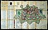
The fortification plan of 1774 by D.G.B. Dalhoff served as a basis for the reconstruction59. This plan includes profiles of the bastions and ravelins. Thus, the 18th-century situation after the improvements of c.1700, including the second envelope, was what was reconstructed, not the 17th-century fortifications seen on the map by Blaeu. It has been argued by the local authorities and by writers of magazine articles that Blaeu's map was, in fact, used to define the old configuration of the fortifications60. However, in Chapter III it was clearly shown that the fortifications in Blaeu's map were depicted fairly accurately but not completly so. The question therefore arises why Grontmij should have used Blaeu's map although there were much more accurate maps available, such as the one by Dalhoff, which was actually used. Here, Blaeu's map probably served only as an instrument of policy. Strangely enough, there is no mention of the very detailed map, with all dimensions written on it, by P.J. de Waal (1842), which must have been available at the time of the restoration61. Had this map been used, the incorrect execution of the connection of the courtine on the south-side near the Herptse Poort could have been prevented62.
Seven of the eight earthen bastions, five ravelins and the moat, the envelope and the waterfront on the Meuse have now been reconstructed. On the eighth bastion we find the shipyard of Verolme, a very important industry for Heusden. A water treatment plant had been installed on this bastion, and this part of the fortifications was therefore left out of the restoration plan. The stone wall near the Town Harbor and the waterfront on which later the Veer Poort was reconstructed with the mills, was also given its old form. Originally, the bastions and courtines were 1.5 meters higher, because the water level of the Meuse used to be much higher. When asked for advice, the Stichting Menno van Coehoorn approved building the fortifications at a lower level provided that the vertical proportions were maintained. Part of the mud and earth that was dug out of the moat was used to raise the bastions, the ravelins and the envelope.
The first phase of the reconstruction of the fortifications (c.1968-1970) concerned the southern part between the Wijkse Poort (including the new marina and passages under the wall) and the Oudheusdense Poort. The second phase included the part between the Oudheusdense Poort and the Herptse Poort. These were finished in 1973. When Heusden was granted Protected Townscape status in 1972, one of the restrictions imposed was that the area around the fortifications should remain free of buildings to ensure a clear view of the fortifications. The last phase, completed around 1990, was the restoration of the western and northern ramparts and the area around the Wiel including the new marina in the Wiel. During the construction, the remnants of the 14th century wall were discovered and were found to be as seen on the map by Van Deventer. They were partly excavated and left visible above the ground level.
In summary, there were already plans for the reconstruction of the fortifications in existence before the Second World War. Even during the period of the Redevelopment Plan (1961) the reconstruction of the fortifications was already being prepared, though it was not considered in the plan itself. The final implementation only took place under pressure from agents outside Heusden: The Stichting Menno van Coehoorn, Bond Heemschut, and the RDMZ.
When the provisional Reconstruction Plan Heusden was officially abandonned and the Redevelopment Plan was not approved it became clear that a new approach would be necessary to solve Heusden's economic problems and prevent further dilapidation. In fact, the committee's critical remarks had already hinted at the requirements which would have to be met for plans to be approved by them. Renouncing high-rise buildings and stressing the importance of the historical structure and buildings, would give plans a better chance of being approved. Thus, the policy shifted and a new architectural and urban planning company was commissioned by local government headed by Mayor Van Delft to draft a plan for redeveloping the built-up area63. This was the architectural and urban planning firm of D. Zuiderhoek, Baarn. Zuiderhoek's assistant, A. Peetoom, would be responsible for drawing up the new plan, while Zuiderhoek would design an extension plan for villages in the municipality64. Prior to the presentation of the Development Plan, Peetoom was given one year to study the infrastructure, the urban structure and the buildings. The starting point for the plan was still redevelopment but it soon turned out that subsidies could only be claimed if the plan involved the entire historic center, with detailed descriptions of functions given for every single plot. So, instead of a new Redevelopment Plan, a Development Plan had to be drawn up.
Development Plan Heusden stad, A. Peetoom 1965
The Development Plan in question had to serve a twofold purpose. It was to be both a protective and a legal planning instrument for further developments. Functions, boundaries, dimensions, etc., were all laid down in detail in a ground plan with a legend, the building regulations, accompanied by an Explanation65. The Explanation provided additional planning maps on the traffic situation, recreational areas, industries, listed buildings and their constructional quality, etc.
The restoration and improvement of Heusden had to be attained while fully respecting the historical aspects of the town. The statement accompanying the project reads as follows: Heusden, as a potential center and residential area, has an extra quality. Many simple but historically remarkable houses and buildings, streets and alleyways, a square with a fascinating use of space, the vast system of ramparts and moats, the Meuse River and the open land outside the fortress make Heusden a monument which has certainly suffered but whose restoration is to the advantage of its inhabitants and its economic development66. Unlike in the Redevelopment Plan, high-rise buildings were no longer allowed.
After extensive research, the architect A. Peetoom presented the Development Plan in 1965, and it was approved by the local authorities on May 31, 196567. The temporary Development Plan became effective on December 27, 1965.
The Development Plan involved:
1. In expectation of an increasing population, the building of
a total of 147 dwellings at various sites, 51 one-family houses,
4 apartments over shops, 68 homes for the elderly, and 28
inserted dwellings. One of the goals was to
increase the number of inhabitants from about 1,800 to 2,500.
2. The realization of the correction of boundaries of plots and
the demolition of out-buildings, so that it would be possible for
premises that were serving as warehouses and the like to be
returned to their original state as homes with gardens.
3. The creation of possibilities for the relocation of businesses
and shops in such a way that suitable premises would be made
available for housing. The unsatisfactory situation, in which
dwellings were situated between slums and warehouses, would cease
to exist.
4. The removal of businesses which disturbed conditions in a
residential area. Those regarded as such were troublesome or
unhygienic businesses and those that increased traffic. In
addition, businesses would be removed whose expansion needs would
lead to the erection of buildings which would be totally out of
place in a residential area due to their size and appearance.
Furthermore, there was a need for a varied and concentrated shopping area, not only for local inhabitants but also for people from Oudheusden and Herpt, so that the town could recover some of its traditional functions as a center. Craftsmen, in particular, were stimulated to occupy the smaller historic buildings. The situation of Heusden on the Meuse River also afforded the opportunity of attracting water-sports tourism planned on both sides of the Town Harbor, for which suitable accommodation should be provided68. In this respect, the appearance of Heusden from the river was considered important.
While preserving the street pattern, it was necessary to solve dangerous traffic situations (Wijkse Poort) and the growing parking problem of a town which attracted tourists. A new street was planned (also included in the Redevelopment Plan) behind the Catharijne Church between the Oudheusdense Poort, the Demer Canal and Putterstraat. Several foot paths would be created.
The official assignment was to design a redevelopment and restoration plan. The buildings had to be restored artistically (or perhaps aesthetically PA) appropriately69. In the Explanation accompanying the Development Plan, however, it was only suggested that restoration of listed buildings could be considered, rehabilitation of the whole town had not yet officially been mentioned70.
The Development Plan was officially approved by the local authorities on March 26, 1969 and by the national government on May 27, 1970. By then, some restoration work had already started. The town architect, A. Peetoom, became supervisor of the restoration of the private houses. He did most of the design work himself. In 1966 the List of Monuments was reviewed and a total of 134 buildings were listed71. In the period after the first presentation of the plan, Heusden received much encouraging publicity in which the qualities of Heusden as a historic town and the motives for the restoration were discussed in detail72. In reaction to these publications, private individuals showed interest in the project by sending postcards, photographs, etc. with representations of Heusden which could be used for the restoration. Many articles written by the then mayor, G.M. Scholten, who was personally very much involved in the restoration, appeared in architectural magazines73. The map by Blaeu was mentioned in most of those magazines as the source for reconstructing Heusden's 17th-century townscape.
The implementation of the 1965 Development Plan
The fact that the fortifications would finally be reconstructed had great influence on the implementation of the Development Plan. The idea began to take shape that reconstruction of the fortifications and restoration of the main monuments alone would not be enough to revive the economy of Heusden. In fact, the whole town needed radical repair. These ideas quickly evolved into the ambition of total restoration involving the whole town, with emphasis on the restoration and rehabilitation of the private houses. The argument was that `the painting itself had to be adapted to the restored framework' (the fortifications PA)74. The town architect, A. Peetoom, had suggested in the Development Plan that the boundaries of the former Town Harbor could be emphasized by means of a 70 centimeter-deep sunken public square75. But in the light of the reconstruction of the fortifications, in 1971 the Town Harbor was re-excavated anayway76. Re-excavation resulted in the rediscovery of parts of the old 18th century quay walls as visible on Tirion's map (1749), which was used for the reconstruction.
Due to a serious maintenance backlog, many buildings were considered for rehabilitation. About 400 dwellings needed to be restored or structurally repaired. Of these, 134 were listed77. Structures often had to be renewed while the interior had to be fitted with modern sanitary facilities, since bathrooms were still lacking in many houses. Buildings which were considered incongruous in the townscape would be demolished and replaced by new buildings in adapted style, i.e. harmonious in scale and texture with their environment. Plans were made to improve the public areas with new pavements, old pumps, street furniture, etc.
Peetoom's double function as an urban designer and a restoration architect enabled him to explore Heusden's complete urban structure as well as the construction and material of the buildings in great detail. Considering this, it is no wonder that it took Peetoom a long time to produce the final development plan. The same thoroughness and dedication can be deduced from the designs for buildings that were considered for rehabilitation. Peetoom documented every architectural and constructional detail, researched the history of each building and consulted many photos and other visual sources78. Many of his dossiers contain detailed documentation and provide all kinds of references79. The artistically/aesthetically appropriate approach to restoration originally chosen became more the historically correct approach in practice80. In order to fill up the gaps in street walls, Peetoom designed ten types of inserted dwellings, which could be adapted in dimensions to each location. The rents of these dwellings were subsidized.
Heusden had chosen not to rehabilitate buildings block by block but to spread the individual projects over town. The accent in the beginning was - naturally - on 17th-century listed buildings of visual importance and on buildings on street corners. In this way, owners of premises next to restored buildings could more easily be persuaded to have their houses restored as well. The ambition of the local authorities to restore the complete town met with some difficulty in the cases of owners who were not willing to spend money on restoration. The local authorities therefore started to buy up as many buildings as possible with the purpose of selling them to new owners with the obligation to restore. Owners could make a claim under the so-called 80% regulation to finance the restoration. Together with subsidies from the RDMZ it was possible for Heusden to continue the restoration at a very fast rate81.
In 1973 the point of no return had been reached82. Now that the effects of the restoration of Heusden had become clear and the project had been accepted at both local and national level, local government became eligible for new subsidies for finishing the work, even more so when, in 1972, the fortress as a whole was designated a Protected Townscape under the Monumentenwet (Monuments Act) of 196183. The explanation accompanying the designation stated that `Since the street pattern and the main structure of the buildings are still intact, the townscape as a whole can be considered to have an important historical authenticity. Protection [...] is justified to preserve this structure of alignment, main forms of buildings, building materials and pavements'.84 Heusden had already met the requirements for drawing up the obligatory Development Plan in 1965 in which functions, scale, material and dimensions of buildings were stated.
During the European Architectural Heritage Year in 1975, when the restoration had been half completed, Heusden was highly praised in the media. It was even one of the few towns designated by the National Committee for the Architectural Heritage Year as a `shining example' of restoration85. In 1978 the of Europa Nostra Foundation gave Heusden an award for `the superb restoration of the old town and its ancient fortifications'86.
Not every detail of the Development Plan was executed. Part of the shopping area planned for Wijksestraat was not realized. The main shopping area is now situated in Botermarkt, Hoogstraat, Engstraat, Vismarkt, and Nieuwstraat. As for the clearing of out-buildings and other buildings within the blocks, some of the buildings appeared to be of interesting quality and therefore not all were demolished. The new street planned between the Demer Canal and Putterstraat was not realized. The two modern high-rise buildings that were considered architecturally incongruous (Pelsestraat and Molenstraat) were not demolished, since the buildings were still structurally very sound. In the same way, the Delft School rows of houses near Burchtterrein were also considered incongruous but were not demolished. Rather than demolition, the policy was changed into the `softening' of incongruous buildings87. At the beginning, the emphasis was on the restoration of the houses and the street walls, the clearing of the interior of the blocks was carried out only much later. Inside the blocks many small out-buildings were demolished, gardens were re-alotted and separated again by 1.8 meter high garden walls, and new garages were built in adapted style.
Buildings were restored using ancient materials which were imported from several places in The Netherlands. These materials were bought from places all over the country where old buildings were being demolished. More than once Mayor Scholten called for the setting up of a warehouse of ancient building materials for the benefit of restoration88. On certain Saturdays, Mayor Scholten, together with inhabitants of Heusden, would clean old bricks so that they were ready for re-use. In this sense, these re-used bricks might well be described as spolia. In this respect the authenticity, mentioned in the register of the Protected Townscape may be questionable.
In accordance with the assignment given by the local authorities, the area of Stadshaven and Vismarkt was given special attention 89. The buildings around the Town Harbor were rehabilitated in an early phase of the restoration.
Although the other restorations were scattered over the town, the north/west-wall (Stadshaven 1-12) was considered by Peetoom and the local authorities as a coherent project and was rehabilitated as such. Peetoom admitted that in order to create a visual unity in style and appearance his approach was sometimes contrary to historical facts. A good example of this is Stadshaven 4. The original moldings which enclosed the windows of this mid-19th-century mansion were completely removed and replaced by 18th-century windows (5x4+3). The front door has an ornamented 18th-century transom. The result is that the building now looks probably older than it is90. Unlike the Delft School houses, two incongruent Jugendstil buildings near the Town Harbor were indeed demolished, the reason given being that they contained bad building materials (chalk-sandstone)91. These houses could have been restored in Jugendstil, rather than reconstructed in accordance with pictures from the turn of the century. The Rates House next to the Fishmarket Hall, demolished in 1904, was reconstructed in a lower form to fit in better in scale and dimensions with the Fishmarket Hall. The cornice of the new Rates House, important for closing the Vismarkt's fourth wall again, was first designed with the same height as the Fishmarket Hall. The building which was finally realized has a cornice slightly higher than the Fishmarket Hall creating a more dynamic image. To enhance the silhouette of the townscape, draw-bridges and three wooden postmills were reconstructed near the waterfront. They were situated on the sites shown on Blaeu's map.
Some of the listed buildings were restored to their original appearance but only where historical traces were available (for instance, Vismarkt 14, Ridderstraat 5, Breestraat 13), leaving out later restorations and additions. However, this did not occur often. Though Breestraat 10, a former town farm, was partly restored to its former appearance (windows on the first floor and the completed stepped gable), it is still possible to read the buildings as a historical document, since traces of buildings material and various kinds of brickwork representing different restorations were left intact. New buildings, for example, a police station, a fire department, homes for the elderly, and inserted dwellings, were built in adapted style. These new adapted dwellings were usually built in brick with coarse pointing, late-18th-century windows and new cornices (Breestraat 29)92. From his designs it appears that Peetoom was challenged to design good dwellings with modern facilities on small ground plans. This often resulted in the replacement of the entrance passage by a small entrance hall. For the addition of a complete bathroom, one bedroom generally had to be sacrificed.
In the view of local government, the discovery of remnants of the old town gate near the Meuse River (Veer Poort) justified the reconstruction of this gate which marked the town's entrance at Waterpoort. Scholten and Peetoom were very much aware that this manner of restoration would be criticized, but they believed that this was the only solution which would guarantee an improvement and re-establish cohesion in the townscape. The more restorations were completed and remains were found, the more work there was to do.
Shortly after 1976, when the Stadshaven and surroundings were finished, the costly, precise, historical way of restoring buildings as well as acts, such as the purchase of postmills, came in to increasing criticism from the RDMZ, critics and art-historians93. At the same time, the municipality was facing different problems. There was an enormous financial deficit which had been worsened by the restoration. The use of old materials had also become increasingly expensive over the years, since more and more towns had started to restore their cultural historical heritage, driving the prizes up94. Repairs and facilities in the other towns which were part of the municipality of Heusden were neglected because most interest was directed towards the restoration of the Protected Townscape. In addition, most of the restoration process took place over the heads of the local authorities (except for Mayor Scholten), with the actual decisions being taken by the RDMZ, the provincial authorities, the town architect and the mayor. The restoration of the original appearance of some of the buildings increasingly met with strong criticism because ideas about restoration had evolved into a preference for the regulations of the Venice Charter95. In the eighties the restoration of Heusden came to be considered a classic example of how it should not be done96. For these reasons the course of the restoration policy was changed97.
Starting from 1974, at the request of the town council and the RDMZ, other architects were given commissions to bring more variety in Heusden's townscape98. In 1965, when the concept of restoration was very new in Heusden99, Peetoom was given a free hand in the design and implementation of the development plan. When other architects, such as Meulenbelt and Verlaan & Bouwstra, started working in Heusden, more specific assignments were given. Peetoom still had the supervision. After Peetoom's resignation in 1979, Zuiderhoek & Van der Veen again became the urban designers, and the architect Meulenbelt (with other architects) took over the architectural work.
In November 1979, Mayor Ter Laak, the successor of Scholten, explained to the national and provincial authorities that the local authorities had taken several measures to reduce the financial deficit by changing its policy. This new policy consisted of slowing down the speed of restoration, using cheaper materials and by terminating the relationship with the town architect100. Though the quality of many of Peetoom's restorations was beyond question, the combined function of architect and urban planner was now deemed unacceptable. The increasing decentralization policy of the RDMZ provided the opportunity for local government to implement a more flexible policy. The firm of urban designers of Zuiderhoek & Van der Veen were asked to draw up a new Development Plan which reflected the local authorities' new policy.
The New Development Plan, D. Zuiderhoek & Van der Veen, 1980.
The new Development Plan (1980) involved, among other things:
- a more flexible policy towards the establishment of new shops
and restaurants;
- the creation of parking lots on the reconstructed bastions and
on a ravelin in front of the Wijkse Poort;
- the restoration of 130 buildings;
- reconstruction of the Wijkse Poort, Herptse Poort, and
Oudheusdense Poort;
- reconstruction of the Demer Tower;
- restoration of the Fishmarket Hall;
- development of the Wiel as a marina;
- reconstruction of the Catharijne Tower, which used to be
important for the image of the townscape.
At the same time, official letters were sent to the architects involved in which they were told to restore economically and soberly. The emphasis of the restoration was now entirely on the exteriors, façades, and roofs. The interior had to be renovated with the utmost simplicity101.
Realizations and further developments
One of the first of the other architects who came to work in Heusden was J.C. Meulenbelt, who worked on various restorations between 1974 and 1986. Meulenbelt was commissioned for most of the restoration and new constructions in the Putterstraat area, between the Catharijne Church and the Demer Canal. He restored the Governor's House off Putterstraat which was later turned into a town museum. New houses in adapted style built near the Demer Canal, fit very well into their surroundings. Some former warehouses were restored as dwellings. All new buildings were constructed in new brick. However, the windows of many former town farms along Putterstraat give the impression that they are old, or reconstructed. The most striking example of change in the urban structure is the transformation of a town farm at Waterpoort into two old-looking dwellings. Though the architect was reluctant to meet the demands of his clients, he finally gave in102. There is no historical justification for the two dwellings that we now find there. They were built in adapted old style but with modern building materials. The new brick used in these two buildings contrasts with the old bricks of the adjacent Waterpoort 16, restored by Peetoom. Though the material shows that the two dwellings are new, the arrangement of the façades, their style, cornices, and windows suggest that they were built in the 17th century. The direction of the parallel roofs, which are at right angles to the street, was derived from Blaeu's map.
Verlaan & Bouwstra started working in Heusden at the time Mayor Ter Laak was calling for economies to be made (about 1979). Due to cutbacks in expenditure, the existing façades were altered or reconstructed in original appearance less than was the case in Peetoom's time. 19th and 20th-century windows were often no longer replaced by an older type even if traces were found. In the rehabilitation of the interior, costly restorations of historical details were strictly forbidden. In this way, although it is possible that this resulted in more authentic elements being preserved, interesting historical interiors were in some cases demolished at the owner's request. This was possible because interiors were not always recognized as protected by law or regulation103. Verlaan & Bouwstra admit that the twin gables which flank Drietrompetterstraat 5 are in fact fancy constructions without any historical justification. The fact that this kind of architecture was realized confirms that the policy had changed.
It is striking that, contrary to what happened in Peetoom's time, commissions were given to the architects to restore and renovate whole blocks of houses or a series of buildings. An example of this is Meulenbelt's commission for buildings in Putterstraat and the Demer Canal and Verlaan & Bouwstra's commission for a series of buildings on the Vismarkt and Drietrompetterstraat block, in Wijksestraat, and in Nieuwstraat.
In 1971 the construction of the harbor and marina again entailed the diversion of the Meuse River. The town became cut off directly from the river by tongues of land, one near the canning factory, one in front of the Town Harbor and the Wiel and one in front of the shipyard. During this period the restoration was continued with new paving and restoration of the streets, side-walks, vegetation and street furniture, garages and brick garden walls104. Series of additional inserted dwellings in brick were realized on open land south-east of Putterstraat. The open land near the Herptse Poort was occupied by schools, new apartment buildings and one-family houses. The many new buildings caused intensification of the urban structure.
The demolition for no apparent reason of a large 19th-century mansion on Waterpoort (nr. 17-37, A125) in 1983 and its replacement by a modern high-rise building indicates that a contemporary style of building was once more acceptable. Though this apartment block is only slightly higher than the mansion that used to be there, the addition of one story, the modern materials and window openings make it seem huge in comparison with the adjacent buildings. In this respect, it should be added that a new harbor tower was built near the Wiel at the end of Putterstraat by architects Van der Laan & Van Hal. At the explicit request of the RDMZ and the local authorities this was done in contemporary style and with contemporary materials. The objections by the Stichting Menno van Coehoorn were ignored105.
In the 1965 Development Plan Peetoom had proposed not to reconstruct the town gates, but rather to restore the old retaining walls in order to re-create the suggestion of town gates at the entrances to the town. But, he made an exception for the Veer Poort and the lower part of the Wijkse Poort since much information about them was available. Nonetheless, after Peetoom had left, the small tower of the Wijkse Poort which was drawn on Blaeu's map next to the gate, was reconstructed on top of the gate. This imaginary tower was apparently based on forms on the other town gates (Herptse Poort and Oudheusdense Poort) seen in Blaeu's map106. The Wijkse Poort could, however, not cope with the traffic. Next to the gate an extra opening in the wall had to be to accommodate it. This received much criticism, because it was contrary to regulations and the Development Plan. The ravelin near the Wijkse Poort was restored, providing parking space. The reconstruction of the Wijkse Poort in 1984 meant the finishing touch of the reconstruction of the fortifications. Plans for reconstructing two other town gates (the Herptse Poort and Oudheusdense Poort) were called off, but the reconstruction of the Demer Tower (Meulenbelt) on a 14th century foundation near The Demer Canal as seen in the maps by Van Deventer and Blaeu was indeed realized in 1985. The Demer Canal itself was re-excavated between Herptsestraat and Lombardstraat.
The remains of the castle discovered below ground level in 1949 were exposed again in 1988 and consolidated. They were consolidated in the sense that some walls were raised a few meters above ground level in order to give an impression of the former castle. Parts were reconstructed in neat new brick107. Though a few restorations remained to be carried out and the reconstruction of the Catharijne Tower had not yet been finished, one could say that the major part of the restoration was completed in 1990. In 1990, the town had only 1,513 inhabitants and 636 buildings. These numbers had increased in 1993 to 1,557 inhabitants and 653 houses. From these figures we can conclude that the goal to increase the number of inhabitants to 2,500 has not been attained.
Although it has been argued that many towns have changed in color due to deplastering during restoration in the nineteen seventies, Heusden is not an extreme example of this practice108. Some individual buildings scattered over town were deplastered but this did not take place on any grand scale. However, the Town Harbor (Stadshaven) and its vicinity form an exception. Here, the most radical changes took place including the deplastering of several buildings. The main street, however, still shows a dynamic alternating view of plastered/painted façades and brick ones. The impression that the town as a whole has become much redder in color is probably due to the fact that all the new social housing and inserted dwellings were built in brick. Besides this, the whole town presents a much refreshed look through the restoration of so many façades (restoration, reconstruction, or cleaning). The contrasts in color have much increased. During the restoration period exterior features of façades were often kept, restored or rebuilt exactly the way they used to be. As material is not displayed, this cannot be seen in the computer images. So even if the computer images show no change, the façades might have been restored exactly the way they were, a fact that enhances our knowledge about which appearance was favored.
The restoration of Heusden can be divided into two periods. The first restoration period (1968-1976) was dominated by the architect Peetoom. He seems to have divided the town into different areas, each with its own character. The area around the Town Harbor and Vismarkt was radically reconstructed in a uniform way so that it formed a unity. The façades of most 17th-century listed buildings were restored to their original appearance based on traces in the building and visual material. Streets like the main street (Breestraat, Botermarkt, Hoogstraat), however, were virtually left intact and not radically changed by Peetoom. Nor were buildings de-plastered to the extent that is generally believed. It appeared that the precise, historical approach later rejected was only applied to the area around the Town Harbor and some individual buildings of historical importance.
After 1976, when other architects like Meulenbelt and Verlaan & Bouwstra were given commissions, the historical approach, as it was realized near the Town Harbor, was abandoned, and façades were treated more cautiously, respecting also later alterations. But, at the same time, anti-historical examples and reconstructions can be found in the construction of some new dwellings in old style (Waterpoort and Drietrompetterstraat), in the reconstruction of the Wijkse Poort and the Demer Tower, in the consolidation of the remains of the castle, and in some new scenic buildings (Putterstraat).
Open spaces in the street walls were filled in with inserted dwellings, and accents were put at the end of streets (town gates, harbor tower). The reconstructed fortifications and the various focal points at the ends of the streets enhance the idea of enclosure. The urban texture seems to have been refined and open/closed areas are better defined, and streets function as a logical routing system through the town. The intensification of building within the fortifications creates a more traditional urban quality in which the street walls are closed with public buildings while the areas within the blocks are semi-private.
4.5 The Management of Heusden's Townscape
So far, we have dealt in this chapter with the way plans were developed and realized in Heusden. Following the previous sections, some of the direct influences on Heusden's developments after the Second World War will be described here in relation to national and international trends in urban planning and the preservation of monuments. Very briefly, we will discuss the roles of national government, local government, some of the architects, and approaches to restoration.
Until after the Second World War, Heusden's building activities did not differ from practice elsewhere in the country. Developments mainly followed current practice. The social housing, the new Town Hall, the new buildings from the reconstruction period, and the Redevelopment Plan bear witness to this. What was new at the beginning of the sixties was the sudden interest in the past and historical qualities.
The authorities in Heusden only became aware of the value of their historic town after interference from the RDMZ, the Stichting Menno van Coehoorn and the Bond Heemschut109. Whereas in the reconstruction period only the most important monuments were restored and dwellings were only repaired, the RDMZ was very much involved in the reconstruction of the fortifications and they severely criticized the Redevelopment Plan. What was important for the town of Heusden was the insistence of the RDMZ on the extant historical structure and their later suggestion that the town might be designated a protected townscape in order to become eligible for more subsidies.
As soon as the restoration was under way, the RDMZ refrained from further active intervention except for providing advise. The architect, Peetoom, was given a free hand in the implementation of the restoration and plans were approved without difficulty by the RDMZ. Even when ideas about restoration had evolved into a rejection of reconstructions, the RDMZ still continued to provide funds for the restoration, funds which were sometimes used for reconstructions. The RDMZ initiated, directed, and financed the restoration at decisive moments. As soon as the restoration was progressing well the RDMZ largely ceased its interference.
Agencies such as the Stichting Menno van Coehoorn and the Bond Heemschut were especially influential with respect to the fortifications. They also followed the restoration process at close range and criticized in their bulletins later events, such as the reconstruction of the Wijkse Poort and the Harbor Tower.
With regard to the influence of local government on the transformation of the townscape, it was Mayor Scholten who for ten years supported and stimulated the continuation of the restoration. Though Mayor Van Delft had given the initial impetus for the rehabilitation of Heusden by commissioning the Development Plan, this plan was initially considered a normal Redevelopment Plan to improve the town's economy. It was only after the RDMZ, the urban designer Zuiderhoek and, most importantly, architect Peetoom had suggested the possibility of restoring the whole town that the local administration started to believe in its implementation. When G.M. Scholten became mayor in 1966, the town council expressed its unanimous request that their new mayor's first priority should be the restoration and rehabilitation of Heusden. Soon, Scholten became as enthusiastic as Peetoom. Scholten involved himself actively in finding subsidies for the rehabilitation of domestic monuments.
In the period 1965-1975 local government strongly supported architect Peetoom's approach to restoration. Indeed, it was beyond question110. They even requested or demanded reconstruction of the old appearance and they proposed building new dwellings in adapted style, in which windows with glazing bars would create a unity between old and new constructions. As a consequence, new buildings had to look old. Innovative design for a new museum or library was not approved by local government. In fact, local government and Scholten in particular wanted to go much further in reconstruction than Peetoom. They also discussed the possibility of excluding all cars from the town. Though they expressed the request that the town should not be a museum town but rather a residential town, they were very much aware that the restored façades and the new watersports facilities would attract tourism as well111. Plans to set up a new casino (the old one, Waterpoort 1a, had been destroyed in 1944) were not approved since local government thought a casino was not appropriate in a restored town. Besides, they were very much afraid that a casino would attrack the wrong kind of people.
Nevertheless, Mayor Scholten and his collegues was very much aware that the restoration of a complete town should only be carried out incidentally, as an example of the image and structure of our historical heritage. Mayor Scholten became a much sought-after individual because of his stimulating conduct and ever-continuing enthusiasm about the restoration. As a member of ICOMOS112, he was often asked to give lectures or write articles in magazines about the restoration of historic towns.
When Ter Laak became mayor in 1976, it had become clear that a new course was going to be followed. Ter Laak lacked the kind of personal involvement and enthusiasm which had characterized Scholten's contribution. In addition, he was under much pressure to solve the town's financial problems. Ter Laak was given the task of replacing the restrictive 1965 Development Plan by one that was more suscepticle to contemporary adaptation. Unlike the earlier plans of local government which envisaged banning cars from the town, the traffic problem was not considered a really serious problem to which a solution had to be found. Ever since Heusden had been designated a protected townscape, restrictions were imposed on any form of change whatsoever. The restoration was continued, but at a slower pace, and the precise, historical method of restoration was abandoned.
In general, it appears that the extent of local government involvement is fundamental for the extent of preservation in protected townscapes113. The more a local government is inclined to preservation, the more of the town will generally be preserved. The same can be said of Heusden, where, as we have seen, the attitude of local government, in particular in the person of G.M. Scholten, was extremely positive towards the preservation and improvement of the characteristics of the old town. It was even excessive, leading to a very detailed mode of restoration, including street furniture, modern "old" shop signs and reconstructed pumps, which were returned to their original locations as given on the sewer map by Boeren (1916).
>From 1970 onward, new, more favorable regulations became available for subsidized building, rehabilitation and restoration114. These regulations had been drawn up by the Ministry of Housing for the rehabilitation and restoration of old inner cities, and were created after several appeals from towns like Heusden which were the first to engage in the process of rehabilitation and urban renewal. From the end of the sixties, there was a drastic increase in expenditure on restoration on a national scale, which reached its peak in 1976115. Heusden's most productive years for restoration, from 1968 to 1976, matched developments elsewhere in the country, although in a more extreme way. Heusden seems to have profited from all the new financial facilities which allowed the restoration to be pursued rapidly. Moreover, the municipality could, via the so-called refinement regulation, recover from national government all the restoration subsidies granted by the municipality to private individuals116.
Nevertheless, the national cut-backs after 1976 affected in this way, first and foremost `luxuries' like the restoration of historic buildings. The restoration of Heusden was also much affected by them. In addition, Heusden's financial deficit had increased significantly. Heusden believed that the parties who had started and stimulated the restoration for almost ten years had an obligation to provide further financial resources for finishing the work117. They did infact provide these funds: as we saw in the previous section, money was still provided by the government not only for the restoration of residential buildings but also for the reconstruction of town gates.
The reconstruction of the fortifications of Heusden was not an isolated case. In Bourtange, for example, the fortifications, together with the former garrison barracks, were completely reconstructed in the ideal, pentagonal townplan in 1964-1974118. In addition, the medieval fortress town of Elburg was reconstructed, and most 19th-century alterations and adaptions were demolished.119 Between 1964 and 1989 the fortifications of Naarden were also restored as a classic example of the New Dutch Fortification System. The restoration included many buildings within the fortifications120.
One of the first towns which started rehabilitating a complete area was Maastricht, with Stokstraat as early as 1954. After some architectural historical research, most buildings were demolished and reconstructed in their old form on the old foundations. Buildings were treated rather radically: removal to another place, completion and correction of façades occurred as well. Houses built after 1900 were not rebuilt. The area inside the town blocks was completely cleared and made communal thus destroying many characteristic houses at the rear121. At the same period (1968-1978), private individuals initiated the rehabilitation of the Bergkwartier in the town of Deventer122. These initiatives started after plans for redevelopment were severely criticized123. A variety of views on the preservation of monuments in the old town can here be seen in one town. The Maastricht approach (demolition and reconstruction) was applied to several domestic monuments. Other monuments were moved to places where they harmonized better. Examples of consolidation, reconstruction, and restoration of the former aspect were juxtaposed while new buildings in adapted or contemporary style filled up open spaces124. By contrast, Orvelte, an agricultural village, was completely frozen in time and was turned into a village of craftsmen125. Together with those towns, Heusden was an early example of the changed ideas in urban planning which resisted the redevelopment policies of the nineteen sixties.
Restoration and reconstruction of historical town centers also took place on an international level. We already mentioned in Chapter I the example of Bologna. This city, which was undergoing restoration at exactly the same time as Heusden, demonstrates much the same approach, such as the reproduction of existing types.
A general problem in the restoration and rehabilitation of complete towns is that only some of the former inhabitants can afford to return to their restored homes. The rent of most restored dwellings was much higher than it was before, and this attracted a different class of people. In some towns the whole population of an area changed. Many people who had moved to the new dwellings in the extension south of Heusden in the fifties and sixties eventually preferred their new homes to the restored town houses. However, the inserted dwellings and, in the second period, social housing and more inserted dwellings had relatively low, subsidized rents. In fact, these inserted dwellings preceded the recognition of the problem of gentrification in the Charter of the European Architectural Heritage 1975. Compared to other towns, the problem of gentrification in Heusden could have been worse: some fifty percent of former inhabitants returned initially to their old homes126.
The influence of the architects on the transformation of the townscape has in fact already been described in the previous section. We therefore limit ourselves here summarizing their inpact.
The most influential architect was A. Peetoom who worked in Heusden from 1964 to 1979. Relatively undisturbed by intervention from the RDMZ or local government, he spent much time and energy in the restoration of every single building. Peetoom was trained at a time when restoration practice prescribed mullioned windows and current practice was much under the influence of the revision of the Basic Principles published in 1953, which provided architects with a more flexible approach to ways of restoration.
As we have seen, Peetoom acquired detailed knowledge of the complete town. Buildings were restored in various ways. One was restoration of the former (i.e., 17th century) aspect, such as Vismarkt 14, always based on traces in the building itself. Another was restoration of part of the former aspect, preserving the documentary value in brickwork and other traces (Breestraat 10). Then, as mentioned before, Stadshaven 4 exemplifies an ahistorical view. However, even when traces of earlier phases were found, they were only restored in a few cases. Thus, we can say that in fact Peetoom did not have a specific approach which was applicable to every building and every project. Instead, his work demonstrates a more pragmatic approach to each specific location taking careful account of its context and fitting in with the total look of the town.
Neither Meulenbelt, Verlaan & Bouwstra or any of the other architects were burdened by such an overall view of what the town should look like. They treated every assignment as a separate case. The requirements to restoring soberly resulted in a more scenic approach, geared toward the exterior image of the town rather than Peetoom's approach of treating the town as a coherent structural unity.
How far Peetoom wanted to go in order to re-create his harmonious "Dutch" town becomes even clearer from his designs that were not realized than from those that were. Some 19th-century neo-style buildings and early 20th-century buildings were considered incongruous with the townscape. In Peetoom's eyes they formed a threat to the unity of the town. Although Peetoom made some alternative designs for other Amsterdam School buildings (Pelsestraat 6, A133; Wijksestraat 11, A242), these plans were not realized.
Meulenbelt turned the stepped gable at the corner of the Stadshaven, which was demolished after the war, into a open terrace for the restaurant of Stadshaven 23. At the request of the owner of the restaurant, the mass of the former building was not rebuilt. Instead, some ruin-like elements were constructed which referred to the building which used to be there. Peetoom had already made some plans which involved the reconstruction of the former building mass with an arcaded terrace. Reconstruction of the mass would have restored the urban structure and would have completed both the missing corner of Vismarkt and Stadshaven.
Large 17th century buildings like Stadshaven 21 and Wijksestraat 34 used to consist of several smaller dwellings. Peetoom proposed an alternative for the façade of three units for Stadshaven 21 (the former hospital), which had consisted of three separate houses, but this plan was not realized. However, the interior of the building was indeed divided into three separate dwellings.
A year before he left (1979), Peetoom was commissioned to make plans for a series of buildings on Wijksestraat. Though he did indeed produce the plans, he was prevented from carrying them out because of his resignation. The commission went to Verlaan & Bouwsta who made use of the plans prepared by Peetoom127. In some cases they followed Peetooms idea's, but not always, as can be seen at Wijksestraat 19/21. Contrary to Peetoom's advice to reconstruct the 19th-century windows with the arched upper part, which was in accordance with the authenticity of the building, six-light sash-windows were partly kept and partly replaced. This approach was in accordance with contemporary ideas of restoration: to keep as much of the existing building as possible (as a historical document) rather than to restore the building's former appearance.
The map by Blaeu has been mentioned several times now as a source of inspiration during the restoration for the architects and planners as well as for local government. The exact role of Blaeu's map in this process is not entirely unambiguous. It is striking that during the first period of the restoration (1968-1978) only the structure of the street pattern and the orientation of the ridges in Blaeu's map were used. Peetoom used Blaeu's map as any historian would: to search for historical evidence where and how the streets, alleys and waterways ran in the past and what the general form of the houses used to be. As has been discussed in Chapter III, except for some minor deficiencies, the map certainly provides good information on these aspects. When we compare the computer model of the Development Plan and its realization with Blaeu's map, reconstruction of the 17th-century image is out of the question. Blaeu's map was only used in general terms, in order to locate the town gates, mills, global house-shapes, etc. Based on the map, the Veer Poort was reconstructed on its foundations, providing a focal point at the end of the view from the Town Hall to the Waterpoort.
During the second period (1978-1990), Blaeu's map appears to have played a different role. At the same time as the restoration of dwellings was being carried out more soberly, landmarks such as the Wijkse Poort (1983), the Demer Tower (1987), as well as the consolidation of the long vanished castle, etc., were being reconstructed based on Blaeu's map. The new harbor tower near the marina of the Wiel has a similar function in the urban structure to that of the Veer Poort: it functions as a focal point at the end of the street (Putterstraat). Whereas the three postmills were still based on historical evidence, in the period after 1978 some imaginary buildings were constructed as pieces of scenery.
Thus, while the map was used only generally by Peetoom, more direct use was made of the Blaeu's map in the second period. The same can be said of the use made by local government. At first the map was put forward as representing the idea of Heusden to be attained in order to gain support for the restoration. In the second period, however, the information of the map was - without proper verification - taken more literally.
In general, Heusden does not appear to have been subject to a consistent, total approach to restoration. Rather, the architects appear to have made more use of current practice than to have followed the national and international guidelines, such as the Venice Charter (1964) or the Charter of the European Architectural Heritage (1975) to the letter. If one thing is sure, it is that except for the harbor tower, contemporary late 20th century architecture has been kept out of Heusden since both restoration and urban renewal were carried out in adapted style or old form. But since Heusden was not the only town that was completely restored, the restoration in itself and the way it was carried out may be said to be the approach current at the time.
Heusden's development after the Second World War was in line with general trends in governmental urban management, though these trends were implemented in a much more extreme way than in other towns. This was chiefly caused by the first restoration period (1968-1976) when Heusden's restoration approach received much encouragement. During this period, all parties involved, local government headed by Mayor Scholten, the town architect Peetoom, the RDMZ, the ministry and provincial authorities, appeared to agree upon the restoration course Heusden was following. For once, there was a consensus with wide public support for the preservation of the townscape in order to improve the image of the town.
It appears to be symptomatic that all the important initiatives on the improvement and restoration of Heusden were taken by people from outside the town: the Mayors Scholten and Ter Laak, Secretary Lith, the architect Peetoom, and other architects, all originally came from elsewhere and were only temporarily involved in Heusden. Had it not been for them, the Government, the RDMZ, and agencies such as the Stichting Menno van Coehoorn and Bond Heemschut, then Heusden would probably have leveled the fortifications and the town would have been completely redeveloped.
Nevertheless, the restoration does not appear to have been based on any real restoration philosophy, since different ways of restoration were implemented during the period as a whole (1965-1990). Less was reconstructed or restored to its former appearance than was hitherto believed. The historical restoration approach, which was so vehemently rejected later, was only applied to the Town Harbor and its surroundings. Despite this, Heusden never lost its reputation with those concerned with the preservation of historic buildings, architectural historians, and critics of being a museum town. However, the present inhabitants now appear quite content with their restored town, which every year attracts more liberally-spending tourists. In this sense, Van der Woud proposes the strategic preservation of monuments: specialist restoration for an elite concerned with the preservation of monuments and superficial restoration for the purposes of tourism128.
After centuries during which there were few changes of importance, the destruction in the Second World War gave the impetus for new, radical changes in the spatial environment in Heusden. After the war, building activities accelerated significantly. The rapid succession of plans, all different in character, and their realizations in the town have left their mark on various locations in the townscape. This was the result first and foremost of three Reconstruction Plans and the Redevelopment Plan, still very much influenced by contemporary trends in urban planning in The Netherlands. Fragmentation and open building schemes were replaced by densification of the urban structure by filling the gaps and using unbuilt-on land. In this way, a link was established with the traditional compact town structure. The Development Plan involved such a radical change and it was initially carried out so rapidly that one can speak of a complete shift in the mental image of the city implemented by planners and the government. Parallels with the developments in the period 1579-1650 as described in Chapter III are evident.
In general, it appears that what was restored was more the 18th-century image rather than that of the 17th century, and this is
shown in the reconstruction of the fortifications. Although in
structure, street pattern, and constructions of buildings, the
town still retains much of its compact 17th-century appearance,
especially in the area bounded by the Demer Canal, the overall
appearance of the historical core is now mostly 18th century. The use of mullioned windows contributes in no small way to this
impression. The restoration entailed the exclusion of genuine
contemporary design until the early nineteen eighties.
Notes:
1. For a more detailed description of Heusden's economy at the beginning of this century, see: Van den Bosch 1972; De Munck 1970.
2. Licenses were issued in 1857 for a gas factory; in 1859 for a saw mill; in 1860 for a factory producing syrup; 1863 for a steam factory, a flour factory, a wire nail factory and a liqueur distillery.
3. Tarticius van Schijndel 1969, 112.
4. Van der Aa 1844, 545.
5. Van den Bosch 1972; De Munck 1970, 47. In 1910 the town of about 1850 inhabitants had 7 bakeries, 8 shoeshops, and 10 butchers.
6. On the restoration of the town hall by J. Gosschalk, see Dossier 77, Streekarchief Heusden.
7. Landré 1884, 218-221.
8. Poort 1954.
9. Fockema Andreae & Ter Kuile 1949, 279-286.
10. Temminck Groll 1957, 81-88.
11. Voorlopige Lijst der Nederlandse Monumenten van Geschiedenis en Kunst, De Provincie Noord Brabant, deel X, Den Haag 1931, 203-213. Mededelingen van de Rijksadviseurs voor monumenten van geschiedenis en kunst, Den Haag 1921.
12. In an anonymous pencil sketch made in 1832, at least the Oudheusdense Poort was still there. They can also still be seen on the cadastral map of 1832. 13. Kasteel 1964, wrote a detailed history of the Meuse near Heusden. For Heusden's situation on the Meuse, see: Thijssen 1989-1991; 1989B.
14. Letter Menno van Coehoorn Foundation. Dossier 1. "Pleidooi voor het behoud van de wallen en grachten om het stadje Heusden". Provinciale Noordbrabantse en 's-Hertogenbossche Courant, 2 juli 1938.
15. De Munck 1970, 60.
16. Commission by J. Kalff (RDMZ), for documenting the towns of Heusden and Hoorn. For a biography of Ferd. B. Jantzen, see: Plan 1965. For the Investigation of Dutch Urban Beauty, see: Van Nispen tot Sevenaer 1949; Meischke 1969, 22.
17. Raadsbesluiten Heusden 1911-1940.
18. Ibidem.
19. Dossier 59-2, Streekarchief Heusden. Documentation on the "disaster of Heusden's Town Hall."
20. Winkelman 1950 describes in detail the dark days in Heusden in 1944.
21. Bouwcentrum Rotterdam 1959, 9-13.
22. Nico van der Laan (1908-1986) received his degree at the Technical University of Delft in 1937. For a description of the architectural firm of Van der Laan, see: Van der Vaart 1991.
23. Toelichting Wederopbouwplan 1946. See, further: Elias (1984), an undergraduate study of the plans and procedures followed in Heusden after World War II.
24. Van der Veken 1947.
25. Council archives: Speech Mayor Van Delft on the occasion of the opening of the new Town Hall, 11 september 1956.
26. Hansen 1956 and 1977.
27. Wattjes 1937, 28-29; 174-179.
28. Between c.1830 and 1875 engineers of the "Ministerie van Waterstaat" (Ministry of Waterways) built many churches with government subsidies. Haslinghuis 1986, 395.
29. Building licenses.
30. Correspondence Dossier 55 -1, 1.853.1 1947.
31. Ibidem.
32. Renaud 1949, and a report in Bulletin KNOB (1949)2, 157.
33. Renaud 1949.
34. Streekarchief Heusden, -1.712.4 nr. 1-4; 1.777.811.22, nr.20. Letter N. van der Laan, March 1950.
35. Notulen Raad 1950-1952. Elias 1984, 13.
36. Streekarchief Heusden, dossier 1.
37. Streekarchief Heusden, dossier 1.853.1, Letter Ministerie van OKW, December 1, 1952.
38. Van der Vaart 1991.
39. Van der Laan 1951. Van der Laan & Van Hal 1980.
40. Streekarchief Heusden dossier 1, Letter 5 July 1956.
41. Dossier 19 - 6, 1.777.811.1, letter 23 april 1958. W.J.G. van Mourik received his degree at the Technical University of Delft, after which he became Urban Planner for the Province of Gelderland and the National Railway. He established himself as an independent architect in 1950. The architectural company of Van Mourik designed several urban plans (Arnhem, Velp, and others).
42. Dossier 20. "Toelichting bij de herziening van het Wederopbouwplan voor de stad Heusden". The term `high-rise' may seem exaggerated, but in the delicate structure of Heusden where the average building has only two or at most three stories, the term is perhaps justified, even for 4 stories of height.
43. Verslag Raadsvergadering 12 juli 1961.
44. Dossier 20-3.
45. Eindhovens Dagblad, 25 November 1961, "Moet Heusden verdrinken in een dak van beton?" Dossier 21-1.
46. Verslag 2e vergadering Kleine Commissie voor de Gemeentelijke Uitbreidingsplannen, 12 januari 1962. In the committee were represented the Government Service for the Preservation of Monuments and Historic Buildings (RDMZ), Ministry of Education, Culture and Science, Gedeputeerde Staten, Provincial Services: Dep. Planning, Dep. of Waterways, Ministry of Housing, "Bond Heemschut", and several aldermen.
47. Letter from Van Mourik to the town council, January 19, 1962. "Wanneer duidelijk was uitgesproken dat vooral de Raad op hoogbouw was gesteld, was dit wellicht in mindere mate een steen des aanstoots geworden dan nu het meer een hobby van mij moet toeschijnen".
48. Raadsbesluit 1963.
49. W.J.G. van Mourik worked in Heusden 1956-1963 and in 1966 he became Professor of Urban Planning at the University of Wageningen.
50. Art.19. Wet Ruimtelijke Ordening.
51. Raadsbesluit 28 Sept. 1964. In 1993, 3,200 people (more than 50% of the total municipality) live in Oudheusden. At least this goal was attained.
52. Plans (which were later partly rejected) in the neighboring town 's-Hertogenbosch for making its center better accessible for traffic probably also influenced Heusden's Redevelopment Plan. Brabants Dagblad, 9 March 1965, criticism of the 's-Hertogenbosch redevelopment plan, see, "Doorbraken in de Bossche binnenstad verkeers-technisch volstrekt onnodig".
53. Stichting Menno van Coehoorn Jaarboeken: 1957, 20-21; 1959, 23; 1960, 24-25; 1961, 29-30; 1962, 35; 1963, 28/29; 1964, 28-29; 1965, 32; 1966, 28-29; 1968, 40-41; 1975, 75-76; 1980/1981, 101; 1983/1984, 50-51; 1985/1986, 208; 1988/1989, 154; 1989/1990, 188; "Bond Heemschut" 1960, 106-107.
54. Streekarchief Heusden, dossier 1.853.1, letter "Heusdens Belang", March 28, 1953. Dossier 1.853.1, Letter Ministerie van OKW, December 1, 1952.
55. Streekarchief Heusden, letter November 9, 1953.
56. Rapport betreffende de restauratie van de vestingwallen, Breda 1960.
57. The fortifications were part of the "Kroondomeinen" of the State.
58. Heemschut 45(1968), 28.
59. D.G.B. Dalhoff, Fortification Plan ARA, title: "Plan van Heusden met de landen daaromheen gelegen", 1774, OPVH 422.
60.. Ten Klooster 1982.
61. P. de Waal, 1842, ARA, OPVH 428.
62. Ten Klooster 1982, 400.
63. 20 december 1963.
64. Notulen van de Raad. Verslag van de bespreking met de stedebouwkundige de heer D. Zuiderhoek op 28 January 1964. Letter 8 februari 1964; Besloten vergadering 18 februari 1964. Zuiderhoek drew up development plans for the villages of Oudheusden, Herpt, Heesbeen, Doeveren and Hedikhuizen.
65. See also Chapter II (2.3); Peetoom, Toelichting op het Bestemmings Plan Heusden Stad 1965.
66. Ibidem.
67. The Development Plan was publicly announced in "Heusden's raad accoord met Saneringsplan", Brabants Nieuwsblad, 3 June 1965.
68. Explanation of the Development Plan 1965, 4-7.
69. Letter 08/04/1964, "Opdracht aan stedebouwkundige Hr. Zuiderhoek" and Raadsbesluiten 28/01/1964.
70. Ibidem, 6.
71. Gemeente Heusden 1975.
72. An extensive collection of articles on this can be found in the Council archives, Dossier 81; 1.853.3. See further for example: Terlouw 1975; Van der Wielen 1977; Lith 1976, Cobouw 4(1976).
73. Scholten 1971; 1973; 1975a; 1975b.
74. Scholten 1975b, 30.
75. Ibidem, 31.
76. This had already been suggested in the official assignment, 08/02/1964.
77. Gemeente Heusden, (1975)7/8, 108-140. Council archives: Dossier 988/989, - 1.853.3.
78. Peetoom 1966 shows his deeper understanding of Heusden's historical structure.
79. Restoration-dossiers, Council archives.
80. Scholten 1971, 1298: "Het gemeentebestuur streeft ernaar aan de hand van oude foto's en tekeningen datgene terug te bouwen wat er eens gestaan heeft, om de harmonie in een totale straatwand te herstellen. Het weet dat deze wijze van nieuwbouw kritiek kan uitlokken doch meent dat, waar de historische gegevens zo duidelijk zijn, een reconstructie verantwoord is, te meer, omdat het er zeker van is, dat het nieuwe gebouw harmonisch meespeelt in het totale stadsbeeld."
81. Nirov 1980, 59-64; 10-102. See also Chapter I, 1.3.
82. In 1973, after five years of restoration, 23 buildings (21 dwellings, the Fishmarket Hall and the Rates House) had been restored and 16 new homes for the elderly, and a new police-station with two dwellings had been built. Another 21 buildings were under construction while 60 more (27 restorations, 33 new buildings) were in preparation. Council archives, Dossier 631.
83. Aanwijzing als Beschermd Stadsgezicht, beschikking van 21 augustus 1972, Ministerie van Cultuur, Recreatie and Maatschappelijk Werk, nr. 163.756.
84. Ibid. "Aangezien dus noch het stratenpatroon, noch de hoofdvormen van de bebouwing in een recent verleden ingrijpende wijzigingen hebben ondergaan, mag aan het stadbeeld als geheel een belangrijke historische authenticiteit worden toegeschreven. De bescherming als bedoeld in artikel 20 van de Monumentenwet, waarbij het mogelijk zal worden om deze structuur in zijn rooilijnenbeloop, hoofdvormen van de bebouwing en materiaalbehandeling zowel van de bebouwing als van de bestrating, te behouden, is derhalve alleszins gerechtvaardigd."
85. The "Nationaal Comité Monumentenjaar 1975" designated Heusden as a "lichtend voorbeeld" for restoration. Scholten 1975B, 40.
86. Laak 1983, 9.
87. Conversation with C. Lith, July 1989.
88. Scholten 1971; 1973; 1975a; 1975b.
89. Letter 08/02/1964.
90. For a similar example, see: Lange Vijverberg 12, Den Haag, in: Denslagen 1987, 12-13. It is, however, possible that the construction behind the façade was older than 1850.
91. Conversation with C. Lith, July 1989.
92. Restauratie Vademecum, 1991/24-47, RV blad 01-19.
93. See for example: Jonker 1971; Dettingmeijer 1976; De Boer 1980; De Boer 1984.
94. Interview with Chr. Lith, in: Cobouw, 1976.
95. See Chapter I, 1.3.
96. De Boer 1984, 19.
97. Ter Laak 1983, 8.
98. Some critics were already talking about "Peetoom's Place", referring to the then popular tv-series: Peyton Place. Dettingmeijer 1976, 77.
99. C.J. Bardet, then working at the RDMZ: "U kunt rustig zeggen dat Heusden begonnen is de schop in de grond te zetten. Zowel financieel en technisch wist men er nog betrekkelijk weinig. Men heeft gewoon een begin gemaakt en vertrouwde op de goede afloop", Dettingmeijer 1976, 73.
100. "Verslag B&W inzake woonhuisrestauraties", 14 november 1979. Letter from Peetoom requesting his dismissal, 23 januari 1979. Council archives, Dossier 631.
101. Dossier 631, letter 29 October 1979.
102. In a conversation Meulenbelt said that, though he was against changing the structure and against the division of the old town farm into two separate dwellings, he eventually gave in, since "an architect has to make a living, too".
103 In fact, interiors are indeed protected by the Monumentenwet. Since the Venice Charter (1964), the description of listed buildings not only applies to the façade and roof but also to the interior.
104. Notulen van de Raad (council minutes) 28 February 1979.
105. Jaarboek Stichting Menno van Coehoorn 1988/1989, 154.
106. Heemschut 58(1981), 157-158.
107. Renaud 1989, 131-133.
108. Denslagen & De Vries 1984, 105-114.
109. Already at the beginning of this century it was apparent that Heusden did not care very much for its historical architecture and details. "De baldaad van Heusden" (An act of wantonness in Heusden) bears witness to this. When the mayor of Heusden wanted to auction the historic silver emblems of the Local Rifle Association (Schuttersdoelen), the architectural historian E.J. Haslinghuis, then a student at Leyden University, tried to prevent it. Dressed in seventeenth-century clothes, Haslinghuis and some friends woke the mayor and other people in the early hours of 9 November 1905 and tried to talk the mayor out of this action. This might be called an early act of "preservation". Bulletin KNOB 1962, 5-6. De Munck 1970, 89-104.
110. Notulen van de Raad, 22 December 1970, 22.
111. Notulen van de Raad 1965-1975.
112. ICOMOS: International Council on Monuments and Sites. Scholten wrote articles, in for example, Goudappel 1977.
113. Derksen et al. 1983.
114. Between 1970 and 1985 some 13262 dwellings (not always listed) were rehabilitated in The Netherlands with these subsidies. See, Denslagen 1990, 32.
115. Dreimuller & Van Engelsdorp Gastelaars 1982, 34.
116. Interview with Scholten, in Brinkgreve 1980, 15-16.
117. Notulen van de Raad, 8 December 1977, 8. Incidentally, this was not the first time that the local government had tried to lay the complete responsibility at the door of the national government, and the provincial authorities. During the plans for the reconstruction of the fortifications in 1957 Heusden pointed out that "If several government agencies insist on preservation of the fortifications, they are obliged to provide the means to put them in good condition". If they did not do so, the fortifications would be leveled. Streekarchief Heusden, Dossier 1.853.1.
118. Bartelds 1973; Bartelds-Boshuizen 1980; Heijligenberg/Overdiep 1968.
119. Van Voorden 1985.
120. Scheltema-Vriezendorp, 1990.
121. Essers 1973.
122. The old town was documented in articles collected in: "Tien jaar stadsherstel" (Ten years of Urban Renewal), Goudappel 1978.
123. Bruggen & Smit 1976; Barbieri 1978.
124. Van Leeuwen 1982, 211-216.
125. Van Swighem 1974, 98-99.
126. Dettingmeijer 1976, 69.
127. Verlaan & Bouwstra were kind enough to lend me part of their Heusden-archives, and I was therefore able to study their plans and realizations in detail.
128. Van der Woud 1990.
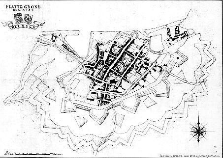
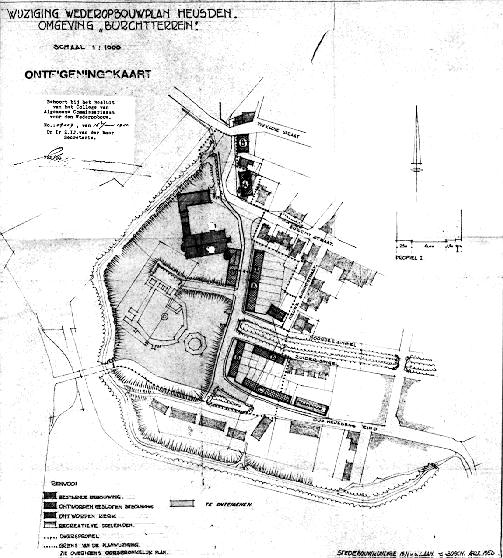
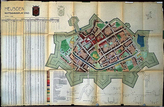
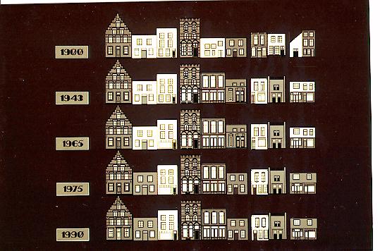
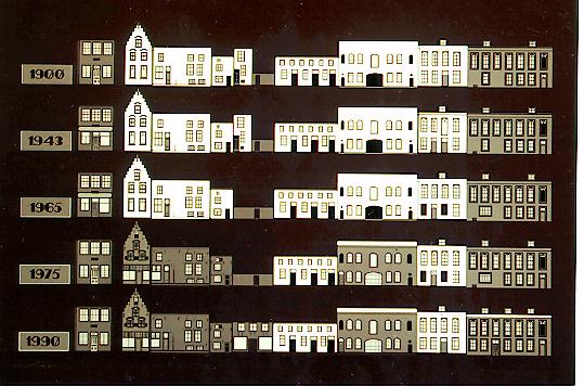
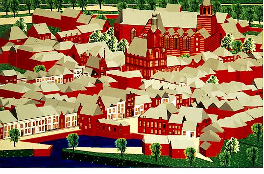
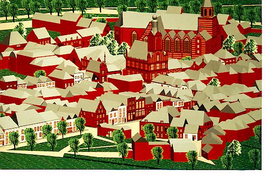
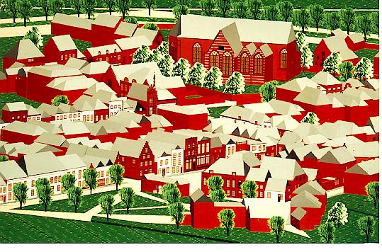
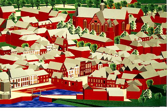
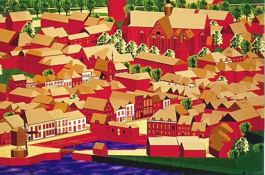